1960s Maps of R Corner, Washington
Explore 2 historic maps of R Corner from the 1960s. These maps offer a rare glimpse into what life looked like during the 1960s — showing old roads, neighborhoods, homes, and landmarks that have changed or disappeared over time.
Whether you're researching your family's past, planning a metal detecting trip, or studying how R Corner's landscape evolved across the 1960s, these high-resolution maps are a powerful tool for exploring the history of this region.
- Focus on a specific era: All maps on this page are from the 1960s, giving you a focused view of this time period.
- See what’s changed: Compare century-old streets, trails, and buildings to today's modern landscape using overlays and satellite layers.
- Research with precision: Use these maps for genealogy, historical research, land use analysis, or educational projects.
- View, download, or print: Maps are fully viewable online in high resolution, and can be downloaded or printed for your own records.
Start exploring R Corner's history through authentic maps from the 1960s. This is your window into the past.
R Corner, WA maps
(2)- 1961 Map of Morse Creek
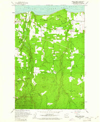 1961 Morse Creek1961 Print · USGSClallam County’s rugged coastline and timbered interior are captured here in the early sixties, showing the reach of the Milwaukee Road. Genealogists and local historians can trace the Cameron Homestead, Fairview Sch, and the Port Angeles Dam.4 unique versions available
 - 1961 Map of Port Angeles, 1962 Print
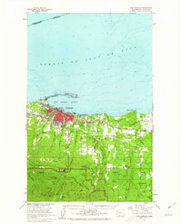 1961 Port Angeles1962 Print · USGSPort Angeles and the Olympic coastline are captured here in the early sixties, showing the city's harbor-driven industry and the nearby wilderness. Researchers can trace family ranchlands like Hambly Ranch, find local landmarks like Fairview Sch, or locate the Cameron Homestead.3 unique versions available
End of results
Showing maps 1-2 of 2
Top cities near R Corner
Frequently asked questions
- What are the different types of historical maps available for R Corner?
- What is the oldest map of R Corner?
- Where can I purchase historical maps of R Corner for my home or office?
- Where can I download high-res historical maps of R Corner?
- Are there historical topographic maps available for R Corner?
- Is there historical aerial imagery available for R Corner?
- Where are historical maps of R Corner sourced from?