Old Maps of New London, Washington
Explore 11 old maps of New London, spanning from 1943 to today. These high-resolution historic maps reveal how streets, neighborhoods, landmarks, and natural features evolved over time — perfect for genealogy, metal detecting, research, and local history exploration.
What you can do with these maps:
- See how New London changed over time: Compare historical maps to modern-day views to trace roads, homesites, rail lines & more.
- View detailed metadata: Each map includes creators, publishers, year, scale, and archive source.
- Overlay maps with satellite & LiDAR: Visualize the past alongside modern tools to explore terrain & human change.
- Trusted historical sources: Maps sourced from the USGS, Library of Congress, and other archives.
- Access maps your way: View online, download high-res files, or order prints for personal or research use.
Start exploring old maps of New London to uncover forgotten places, hidden landmarks, and the deep history beneath your feet.
New London, WA maps
(11)- 1943 Map of Humptulips
 1943 Humptulips1943 Print · USGSGrays Harbor County timber and ranching lands come into focus during the early 1940s as the region transitioned toward modern infrastructure. Researchers can locate family homesteads like Brittain Ranch, industrial sites like the Polson Logging Company lines, and local hubs including Springfield Sch and New London.
 - 1955 Map of Humptulips, 1957 Print
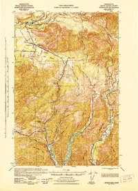
 1955 Humptulips1957 Print · USGSThe Olympic Peninsula timber and river country comes alive in the mid-fifties, showing the intersection of industrial logging and early settlement. Trace family roots and old timber operations near Humptulips, New London, and the Logging Railroad.3 unique versions available
 - 1958 Map of Seattle, 1966 Print
 1958 Seattle1966 Print · USGSThe Puget Sound region in the mid-fifties showcases a balance of urban growth and Olympic wilderness. Trace the industrial waterfronts of Tacoma, old naval facilities like Keyport Naval Res, and mountain peaks like Mount Constance.3 unique versions available
 - 1962 Map of Seattle
 1962 Seattle1962 Print · USGSThe Puget Sound region and Olympic Peninsula are shown at a peak of mid-century growth. Genealogists and historians can trace rail lines like the Pacific Coast RR or locate landmarks such as Fort Lawton and the Bothell Power Station.
 - 1988 Map of Shelton
 1988 Shelton1988 Print · USGSThe Olympic Peninsula's transition from high mountain wilderness to Puget Sound tideflats is captured here in the late eighties. Researchers can trace the path of the Logging Railroad or locate historical sites like Sanderson Field and the Skokomish Indian Reservation.
 - 1990 Map of New London
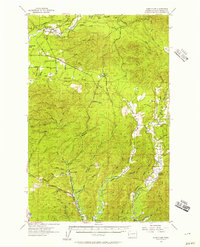
 1990 New London1990 Print · USGSGrays Harbor County at the start of the nineties reveals a landscape of industrial watersheds and timber-country transit. Historians can trace the Old Railroad Grade and locate local landmarks like the Hoquiam Water Works and New London.
 - 2011 Map of New London, 2011 Print
 2011 New London2011 Print · USGSCovers New London, including Hoquiam, Woodlawn, and other nearby areas
 - 2014 Map of New London, 2014 Print
 2014 New London2014 Print · USGSCovers New London, including Hoquiam, Woodlawn, and other nearby areas
 - 2017 Map of New London, 2017 Print
 2017 New London2017 Print · USGSCovers New London, including Hoquiam, Woodlawn, and other nearby areas
 - 2020 Map of New London, 2020 Print
 2020 New London2020 Print · USGSCovers New London, including Hoquiam, Woodlawn, and other nearby areas
 - 2023 Map of New London, 2023 Print
 2023 New London2023 Print · USGSGrays Harbor County at the edge of the Pacific drainage is documented here in the early twenty-first century. Researchers can trace the forks of the Hoquiam River and locate landmarks like the Hoquiam Water Works or the settlement of New London.
End of results
Showing maps 1-11 of 11
Top cities near New London
- Aberdeen historical maps
- Hoquiam historical maps
- Ocean Shores historical maps
- Westport historical maps
- Cosmopolis historical maps
- Aberdeen Gardens historical maps
See more
Frequently asked questions
- What are the different types of historical maps available for New London?
- What is the oldest map of New London?
- Where can I purchase historical maps of New London for my home or office?
- Where can I download high-res historical maps of New London?
- Are there historical topographic maps available for New London?
- Is there historical aerial imagery available for New London?
- Where are historical maps of New London sourced from?