1900s (20th Century) Maps of South Montesano, Washington
Explore 9 historic maps of South Montesano from the 1900s (20th Century). These maps offer a rare glimpse into what life looked like during the 1900s — showing old roads, neighborhoods, homes, and landmarks that have changed or disappeared over time.
Whether you're researching your family's past, planning a metal detecting trip, or studying how South Montesano's landscape evolved across the 1900s, these high-resolution maps are a powerful tool for exploring the history of this region.
- Focus on a specific era: All maps on this page are from the 1900s, giving you a focused view of this time period.
- See what’s changed: Compare century-old streets, trails, and buildings to today's modern landscape using overlays and satellite layers.
- Research with precision: Use these maps for genealogy, historical research, land use analysis, or educational projects.
- View, download, or print: Maps are fully viewable online in high resolution, and can be downloaded or printed for your own records.
Start exploring South Montesano's history through authentic maps from the 1900s. This is your window into the past.
South Montesano, WA maps
(9)- 1940 Map of Montesano
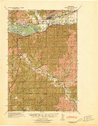 1940 Montesano1940 Print · USGSGrays Harbor and Pacific counties were defined by a massive river-and-rail network just before the war. You can trace the path of the Northern Pacific through Montesano or locate old timber operations along the Logging lines near Arctic and Vesta.
 - 1953 Map of Hoquiam
 1953 Hoquiam1953 Print · USGSSouthwest Washington in the early fifties shows a landscape shaped by timber, rail, and river commerce from the coast to the Cascades. Genealogists and historians can trace the development of timber towns like Ryderwood and the industrial hubs of Hoquiam and Kelso.2 unique versions available
 - 1955 Map of Montesano, 1957 Print
 1955 Montesano1957 Print · USGSThe river-and-rail hub of Montesano is captured here in the mid-fifties as the timber economy shaped the Chehalis valley. Genealogists can trace family names at Brick Ch or locate vanished sites like Artic and the rural community of Brooklyn.3 unique versions available
 - 1957 Map of Hoquiam
 1957 Hoquiam1957 Print · USGSCoastal timber ports and inland rail hubs define Southwest Washington during the late fifties. Genealogists can trace early twentieth-century settlements like Bordeaux, Tono, and Cosmopolis alongside the expanding tracks of the Northern Pacific.
 - 1958 Map of Hoquiam, 1969 Print
 1958 Hoquiam1969 Print · USGSSouthwest Washington and the Columbia River estuary appear here in the mid-century, before major landscape shifts. Researchers can trace the rail lines of the Northern Pacific, locate the Fort Henness Site, or explore the Naselle Air Force Station.2 unique versions available
 - 1962 Map of Hoquiam
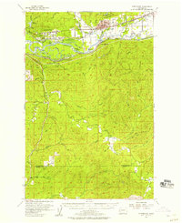
 1962 Hoquiam1962 Print · USGSSouthwest Washington in the late fifties is defined by the bustling timber ports of Hoquiam and the rail-linked commerce of the interior valleys. Genealogists and historians can trace the early footprints of settlements like Raymond and Pe Ell, or locate family sites at Grand Mound Cem and Odd Fellows Cem.
 - 1965 Map of Montesano, 1988 Print
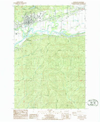 1965 Montesano1988 Print · USGSThe Grays Harbor timber and river country comes into focus in the 1980s, centered on the historic county seat at the confluence of rail and water. Researchers can trace the layout of Montesano, find local burial sites at the Cemetery, and locate old industrial marks like the Smith Canal and the Burlington Northern line.
 - 1986 Map of Montesano, 1993 Print
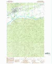 1986 Montesano1993 Print · USGSGrays Harbor County’s riverfront comes into focus during the mid-1980s as the Chehalis River valley balances industry and recreation. Researchers can trace property lines and landmarks from Montesano to Melbourne, including Lake Sylvia State Park and the local Cem.
 - 1992 Map of Chehalis River, 1993 Print
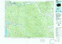 1992 Chehalis River1993 Print · USGSThe Chehalis River valley and the timberlands of the Black Hills are captured here in the early nineties. Researchers can trace rail-and-river history through Montesano and Raymond, or locate the unique Mima Mounds and Bordeaux.2 unique versions available
End of results
Showing maps 1-9 of 9
Top cities near South Montesano
- Aberdeen historical maps
- Montesano historical maps
- Elma historical maps
- Cosmopolis historical maps
- Aberdeen Gardens historical maps
Frequently asked questions
- What are the different types of historical maps available for South Montesano?
- What is the oldest map of South Montesano?
- Where can I purchase historical maps of South Montesano for my home or office?
- Where can I download high-res historical maps of South Montesano?
- Are there historical topographic maps available for South Montesano?
- Is there historical aerial imagery available for South Montesano?
- Where are historical maps of South Montesano sourced from?