1980s Maps of Appleton, Washington
Explore 2 historic maps of Appleton from the 1980s. These maps offer a rare glimpse into what life looked like during the 1980s — showing old roads, neighborhoods, homes, and landmarks that have changed or disappeared over time.
Whether you're researching your family's past, planning a metal detecting trip, or studying how Appleton's landscape evolved across the 1980s, these high-resolution maps are a powerful tool for exploring the history of this region.
- Focus on a specific era: All maps on this page are from the 1980s, giving you a focused view of this time period.
- See what’s changed: Compare century-old streets, trails, and buildings to today's modern landscape using overlays and satellite layers.
- Research with precision: Use these maps for genealogy, historical research, land use analysis, or educational projects.
- View, download, or print: Maps are fully viewable online in high resolution, and can be downloaded or printed for your own records.
Start exploring Appleton's history through authentic maps from the 1980s. This is your window into the past.
Appleton, WA maps
(2)- 1982 Map of Hood River, 1983 Print
 1982 Hood River1983 Print · USGSThe Columbia River Gorge in the early eighties shows a landscape shaped by massive hydroelectric projects and deep-rooted timber communities. Researchers can trace the rail-and-river network through Cascade Locks and The Dalles Dam, or explore the terrain of Gifford Pinchot National Forest.
 - 1983 Map of Appleton
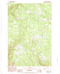 1983 Appleton1983 Print · USGSKlickitat County was a landscape of remote settlements and vital water sources in the early eighties. Researchers can trace the rural infrastructure of Appleton and Snowden or locate isolated landmarks such as the AIRSTRIP and Baker Spring.
End of results
Showing maps 1-2 of 2
Top cities near Appleton
- The Dalles historical maps
- Hood River historical maps
- White Salmon historical maps
- Chenowith historical maps
- Bingen historical maps
- Mosier historical maps
Frequently asked questions
- What are the different types of historical maps available for Appleton?
- What is the oldest map of Appleton?
- Where can I purchase historical maps of Appleton for my home or office?
- Where can I download high-res historical maps of Appleton?
- Are there historical topographic maps available for Appleton?
- Is there historical aerial imagery available for Appleton?
- Where are historical maps of Appleton sourced from?