1980s Maps of B Z Corner, Washington
Explore 2 historic maps of B Z Corner from the 1980s. These maps offer a rare glimpse into what life looked like during the 1980s — showing old roads, neighborhoods, homes, and landmarks that have changed or disappeared over time.
Whether you're researching your family's past, planning a metal detecting trip, or studying how B Z Corner's landscape evolved across the 1980s, these high-resolution maps are a powerful tool for exploring the history of this region.
- Focus on a specific era: All maps on this page are from the 1980s, giving you a focused view of this time period.
- See what’s changed: Compare century-old streets, trails, and buildings to today's modern landscape using overlays and satellite layers.
- Research with precision: Use these maps for genealogy, historical research, land use analysis, or educational projects.
- View, download, or print: Maps are fully viewable online in high resolution, and can be downloaded or printed for your own records.
Start exploring B Z Corner's history through authentic maps from the 1980s. This is your window into the past.
B Z Corner, WA maps
(2)- 1982 Map of Hood River, 1983 Print
 1982 Hood River1983 Print · USGSThe Columbia River Gorge in the early eighties shows a landscape shaped by massive hydroelectric projects and deep-rooted timber communities. Researchers can trace the rail-and-river network through Cascade Locks and The Dalles Dam, or explore the terrain of Gifford Pinchot National Forest.
 - 1983 Map of Northwestern Lake
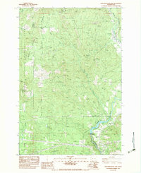 1983 Northwestern Lake1983 Print · USGSThe White Salmon River canyon in the early eighties serves as a rugged backdrop for timber and utility infrastructure. Genealogists and hikers can locate the B Z Corner settlement, the Nestor Peak Look Out House, and the historic Lumber Flume.
End of results
Showing maps 1-2 of 2
Top cities near B Z Corner
Frequently asked questions
- What are the different types of historical maps available for B Z Corner?
- What is the oldest map of B Z Corner?
- Where can I purchase historical maps of B Z Corner for my home or office?
- Where can I download high-res historical maps of B Z Corner?
- Are there historical topographic maps available for B Z Corner?
- Is there historical aerial imagery available for B Z Corner?
- Where are historical maps of B Z Corner sourced from?