Old Maps of Mazama, Washington
Explore 7 old maps of Mazama, spanning from 1955 to today. These high-resolution historic maps reveal how streets, neighborhoods, landmarks, and natural features evolved over time — perfect for genealogy, metal detecting, research, and local history exploration.
What you can do with these maps:
- See how Mazama changed over time: Compare historical maps to modern-day views to trace roads, homesites, rail lines & more.
- View detailed metadata: Each map includes creators, publishers, year, scale, and archive source.
- Overlay maps with satellite & LiDAR: Visualize the past alongside modern tools to explore terrain & human change.
- Trusted historical sources: Maps sourced from the USGS, Library of Congress, and other archives.
- Access maps your way: View online, download high-res files, or order prints for personal or research use.
Start exploring old maps of Mazama to uncover forgotten places, hidden landmarks, and the deep history beneath your feet.
Mazama, WA maps
(7)- 1955 Map of Concrete, 1967 Print
 1955 Concrete1967 Print · USGSThe North Cascades in the mid-fifties reveal a landscape of deep glacier-fed lakes and riverside timber towns. You can trace the Great Northern rail lines through Granite Falls or locate remote outposts like Stehekin and Marblemount along the Skagit and Chelan waters.
 - 1958 Map of Concrete
 1958 Concrete1958 Print · USGSThe North Cascades and Skagit Valley are captured here in the late fifties, showing a landscape defined by glacier-carved peaks and river-bottom settlements. Genealogists and historians can locate remote mining sites like Holden Mine and mountain outposts such as Stehekin, Marblemount, and Mazama.2 unique versions available
 - 1962 Map of Concrete
 1962 Concrete1962 Print · USGSThe Northern Cascades in the early sixties reveal a landscape of high alpine peaks and deep river valleys before the modern park era. Genealogists and historians can trace rail-and-river towns like Concrete, Darrington, and Stehekin, alongside industry at the Holden Mine.
 - 1962 Map of Mazama, 1964 Print
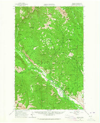 1962 Mazama1964 Print · USGSThe Methow Valley high country is captured here in the early sixties, showing a landscape defined by forest service outposts and early recreation. Search for vanished trails and historic sites like the Early Winters Ranger Station, Lost River Landing Strip, and Billy Goat Corral.
 - 1991 Map of Mazama
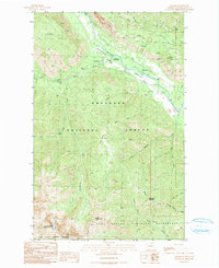 1991 Mazama1991 Print · USGSMazama and the upper Methow Valley are shown here in the early nineties, revealing a landscape of high-mountain recreation and legacy mining. Historians can trace late-century land use through labels like Early Winters Campground, numerous Prospect sites, and Cedar Falls.
 - 2002 Map of Mazama, 2006 Print
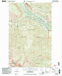 2002 Mazama2006 Print · USGSThe Methow Valley and its high-elevation wilderness are documented here at the turn of the century. Explore the intersection of the North Cascades Scenic Highway with local landmarks like Mazama, the Goat Wall, and various mountain Prospect sites.
 - 2023 Map of Mazama, 2023 Print
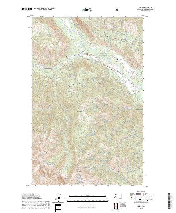 2023 Mazama2023 Print · USGSMazama and the upper Methow Valley are shown in 2023 during a period of modern recreation and forest management. Researchers can trace the paths of the Methow Community Trl and Varden Lake Trl through the Okanogan National Forest.
End of results
Showing maps 1-7 of 7
Top cities near Mazama
Frequently asked questions
- What are the different types of historical maps available for Mazama?
- What is the oldest map of Mazama?
- Where can I purchase historical maps of Mazama for my home or office?
- Where can I download high-res historical maps of Mazama?
- Are there historical topographic maps available for Mazama?
- Is there historical aerial imagery available for Mazama?
- Where are historical maps of Mazama sourced from?