Old Maps of Hamilton, Washington for Academic Research
Study the evolution of Hamilton with 16 high-resolution historic maps. Whether you're teaching, researching, or modeling changes in land use, these maps provide essential visual documentation of urban, environmental, and geographic change.
- Analyze long-term change: Track patterns in development, transportation, and natural features.
- Ideal for environmental or urban studies: Support academic projects with primary historical map data.
- Use in the classroom or lab: Educators and researchers rely on these maps to bring historical context to life.
These maps are a powerful tool for teaching, research, and visualizing how Hamilton has changed over the decades.
Hamilton, WA maps
(16)- 1909 Map of Mt Baker
 1909 Mt Baker1909 Print · USGSThe North Cascades were undergoing a transformation into an industrial frontier during the first decade of the twentieth century. Researchers can trace early railroad lines like the Great Northern and identify vanished logging or mining sites such as Morovits Ranch and the Excelsior Power Plant.3 unique versions available
 - 1915 Map of Mt. Baker, 1925 Print
 1915 Mt. Baker1925 Print · USGSUpper Whatcom and Skagit counties are seen here in the early twentieth century as railroads and mines began to pierce the wilderness. Genealogists and historians can locate early homesteads like Morovits Ranch, the Lone Jack Mine, and the route of the Great Northern railroad.3 unique versions available
 - 1921 Map of Wickersham
 1921 Wickersham1921 Print · USGSThe Skagit and Samish river valleys come alive in this map from the early twenties, showcasing a landscape of timber, mines, and rail. Genealogists and historians can trace the foundations of local life at Northern State Hospital, the Lyman Ferry, and the Cokedale Mine.2 unique versions available
 - 1951 Map of Wickersham, 1953 Print
 1951 Wickersham1953 Print · USGSSkagit County in the early fifties shows a landscape of river-valley industry and timber outposts along the Skagit River. Genealogists and historians can locate the Northern State Hospital, trace the Cokedale Mine, and find rural centers like Samish School.3 unique versions available
 - 1952 Map of Hamilton, 1954 Print
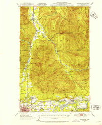
 1952 Hamilton1954 Print · USGSThe Skagit River valley was a bustling corridor of rail and river industry in the early fifties, anchored by the towns of Hamilton and Concrete. Genealogists and historians can trace the GREAT NORTHERN line through Birdsview, find the local High School, or locate the Cem and Dalles Bridge.3 unique versions available
 - 1955 Map of Concrete, 1967 Print
 1955 Concrete1967 Print · USGSThe North Cascades in the mid-fifties reveal a landscape of deep glacier-fed lakes and riverside timber towns. You can trace the Great Northern rail lines through Granite Falls or locate remote outposts like Stehekin and Marblemount along the Skagit and Chelan waters.
 - 1957 Map of Victoria, 1960 Print
 1957 Victoria1960 Print · USGSThe San Juan Islands and the North Cascades coastline are shown in detail during the late fifties, a period of significant military and industrial presence. Researchers can trace historic rail lines like the Great Northern or locate sites such as the Whidbey Island Naval Air Sta and Friday Harbor.4 unique versions available
 - 1958 Map of Concrete
 1958 Concrete1958 Print · USGSThe North Cascades and Skagit Valley are captured here in the late fifties, showing a landscape defined by glacier-carved peaks and river-bottom settlements. Genealogists and historians can locate remote mining sites like Holden Mine and mountain outposts such as Stehekin, Marblemount, and Mazama.2 unique versions available
 - 1962 Map of Concrete
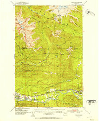
 1962 Concrete1962 Print · USGSThe Northern Cascades in the early sixties reveal a landscape of high alpine peaks and deep river valleys before the modern park era. Genealogists and historians can trace rail-and-river towns like Concrete, Darrington, and Stehekin, alongside industry at the Holden Mine.
 - 1973 Map of Hamilton, 1974 Print
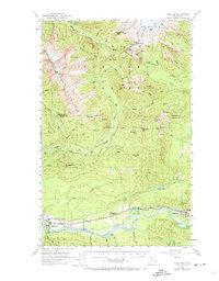 1973 Hamilton1974 Print · USGSThe Skagit River valley in the early fifties shows a bustling industrial corridor shaped by rail and timber. Researchers can trace the Northern Great Railway through Hamilton, find the old High School in Concrete, or locate the Birdsview Siding.2 unique versions available
 - 1975 Map of Bellingham, 1977 Print
 1975 Bellingham1977 Print · USGSNorthwest Washington in the mid-seventies is captured here, from the Canadian border at Blaine to the San Juan Islands. Researchers can trace tribal lands on the Lummi Indian Reservation, find rural settlements like Cokedale, or follow the Burlington Northern rail lines.
 - 1979 Map of Mt. Baker, 1980 Print
 1979 Mt. Baker1980 Print · USGSThe North Cascades in the late 1970s are defined here by high-altitude glaciers and the industrial river valleys of the Skagit. Researchers can trace the rail corridors of the Burlington Northern Railroad and locate mining history at Red Mountain Mine and Silver Lake Mine.
 - 1980 Map of Lyman
 1980 Lyman1980 Print · USGSSkagit County’s timber and rail corridor comes alive in this late-century study of the river valley. Genealogists and local historians can trace family-named landmarks and infrastructure from the Hamilton Cemetery to the Lyman Ferry (Site).2 unique versions available
 - 1989 Map of Hamilton
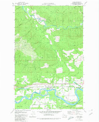
 1989 Hamilton1989 Print · USGSSkagit County in the late eighties reveals a landscape of river-dependent settlements and industrial corridors along the Skagit Valley. Genealogists and historians can locate a local Cem, the Birdsview Siding rail feature, and landmarks like Marietta Falls and Careys Lake.
 - 2023 Map of Hamilton, 2023 Print
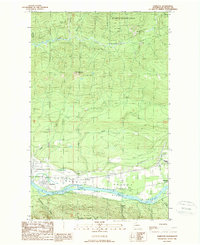
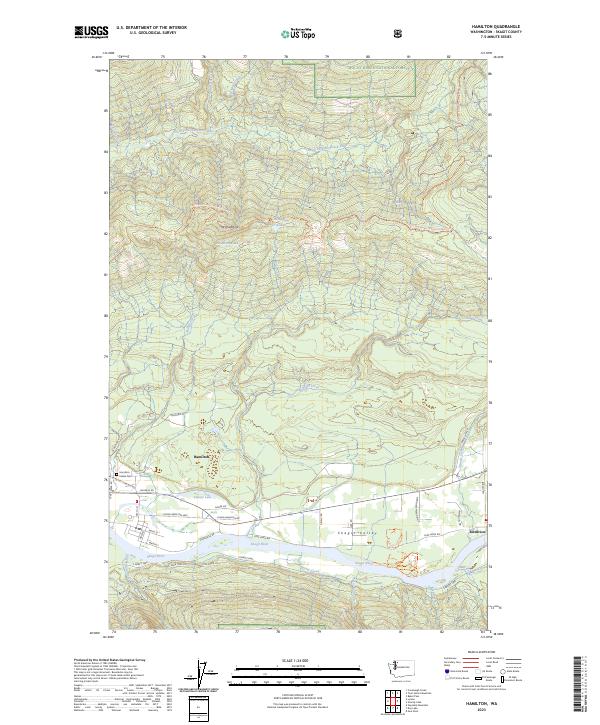 2023 Hamilton2023 Print · USGSThe Skagit Valley floor near Hamilton and Birdsview shows a landscape defined by river life and timber transport during the early twenty-first century. Genealogists and local historians can locate the Hamilton Indian Cemetery and trace industrial routes like the Crown Pacific Mainline.
 - 2023 Map of Lyman, 2023 Print
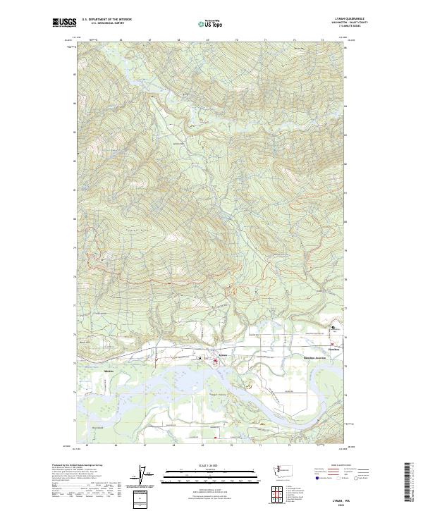 2023 Lyman2023 Print · USGSThe Skagit River valley comes into focus during the early 2020s, showing the riverside communities of Lyman and Hamilton. Researchers can trace rural cemetery locations at Lyman Cem, follow the Pacific Northwest National Scenic Trail, and locate landmarks like Ross Island.
End of results
Showing maps 1-16 of 16
Top cities near Hamilton
Frequently asked questions
- What are the different types of historical maps available for Hamilton?
- What is the oldest map of Hamilton?
- Where can I purchase historical maps of Hamilton for my home or office?
- Where can I download high-res historical maps of Hamilton?
- Are there historical topographic maps available for Hamilton?
- Is there historical aerial imagery available for Hamilton?
- Where are historical maps of Hamilton sourced from?