Old Maps of Sutton, Washington for Genealogy
Trace your family roots with 7 historic maps of Sutton. These high-res maps reveal old neighborhoods, homesites, landmarks, and streets — helping you uncover where your ancestors lived and how the area evolved over time.
- Explore historic neighborhoods: Identify where your relatives may have lived in the 1800s or 1900s.
- Compare maps over time: Trace the changes in streets, buildings, and landmarks for multi-generational research.
- Perfect for genealogy & ancestry research: Used by family historians and researchers to map out lineage and migration.
These maps are an incredible resource for exploring your personal connection to Sutton's past.
Sutton, WA maps
(7)- 1950 Map of La Crosse
 1950 La Crosse1950 Print · USGSWhitman County's wheat-growing heartland is captured here in the mid-twentieth century as the rail-and-river economy flourished. You can trace the Union Pacific line through Winona and La Crosse, or locate rural landmarks like Pampa Pond and the Airway Beacon.2 unique versions available
 - 1952 Map of La Crosse
 1952 La Crosse1952 Print · USGSWhitman County's Palouse hills and deep creek flats are captured here in the early fifties, showing a landscape shaped by water and rail. Genealogists and rail historians can trace the Union Pacific line through La Crosse, Winona, and the small siding at Pampa.
 - 1955 Map of Pullman, 1963 Print
 1955 Pullman1963 Print · USGSThe Palouse and Clearwater regions are captured here in the mid-1950s, showing the height of the rail-and-river economy. Genealogists and historians can trace rail lines like the Camas Prairie RR, find local landmarks like Whitman County Memorial Cem, and locate early academic centers at Washington State University and the University of Idaho.3 unique versions available
 - 1958 Map of Pullman
 1958 Pullman1958 Print · USGSThe Palouse and Clearwater regions are captured here in the late fifties, showing the vital river-and-rail connection between eastern Washington and northern Idaho. Local historians can trace the paths of the Camas Prairie RR and Union Pacific RR as they serve towns like Colfax, Kamiah, and Nezperce.2 unique versions available
 - 1981 Map of Winona
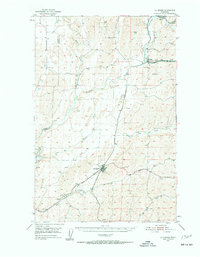
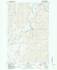 1981 Winona1981 Print · USGSWhitman County in the early eighties shows a landscape shaped by the rail-and-river economy of the Palouse region. Local researchers can trace the rail sidings and grain infrastructure at Winona or locate family sites near Winona Cemetery and Sutton.
 - 1982 Map of Pullman
 1982 Pullman1982 Print · USGSThe Palouse region and Snake River valley are shown in the early eighties as the river navigation system matured. Trace the rail lines of the Union Pacific, locate rural centers like Johnson and Colton, and see the impact of the Lower Granite Dam.
 - 2023 Map of Winona, 2023 Print
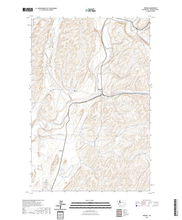 2023 Winona2023 Print · USGSWinona and the Palouse River valley are captured in this modern survey of eastern Washington's high plateau. Genealogists and local historians can trace family-named roads like Jim Knott Rd and locate landmarks such as the Winona Cem and Sutton.
End of results
Showing maps 1-7 of 7
Top cities near Sutton
Frequently asked questions
- What are the different types of historical maps available for Sutton?
- What is the oldest map of Sutton?
- Where can I purchase historical maps of Sutton for my home or office?
- Where can I download high-res historical maps of Sutton?
- Are there historical topographic maps available for Sutton?
- Is there historical aerial imagery available for Sutton?
- Where are historical maps of Sutton sourced from?