1950s Maps of Brooke County, West Virginia
Explore 9 historic maps of Brooke County from the 1950s. These maps offer a rare glimpse into what life looked like during the 1950s — showing old roads, neighborhoods, homes, and landmarks that have changed or disappeared over time.
Whether you're researching your family's past, planning a metal detecting trip, or studying how Brooke County's landscape evolved across the 1950s, these high-resolution maps are a powerful tool for exploring the history of this region.
- Focus on a specific era: All maps on this page are from the 1950s, giving you a focused view of this time period.
- See what’s changed: Compare century-old streets, trails, and buildings to today's modern landscape using overlays and satellite layers.
- Research with precision: Use these maps for genealogy, historical research, land use analysis, or educational projects.
- View, download, or print: Maps are fully viewable online in high resolution, and can be downloaded or printed for your own records.
Start exploring Brooke County's history through authentic maps from the 1950s. This is your window into the past.
Brooke County, WV maps
(9)- 1951 Map of Canton
 1951 Canton1951 Print · USGSThe industrial heartland of Ohio and Pennsylvania reached its mid-century peak during this era of heavy rail and river transit. Genealogists and historians can trace the development of steel towns like Aliquippa and Weirton alongside the Ohio River and major lines of the Pennsylvania RR.
 - 1953 Map of Canton
 1953 Canton1953 Print · USGSThe industrial heartland of Ohio and Pennsylvania is captured at its mid-century peak in this detailed regional survey. Genealogists and historians can trace the vast rail networks of the Pennsylvania RR and find local landmarks like Nimisila Reservoir and Tappan Reservoir.
 - 1957 Map of Tiltonsville, 1959 Print
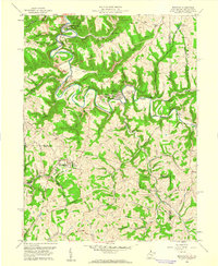
 1957 Tiltonsville1959 Print · USGSThe industrial Ohio River valley is captured here in the late fifties, showcasing the dense rail-and-river network of the Jefferson and Brooke County border. Researchers can trace family roots through sites like Hopewell Cem or explore the mid-century layout of Tiltonsville and the Wheeling-Ohio County Airport.2 unique versions available
 - 1957 Map of Canton, 1971 Print
 1957 Canton1971 Print · USGSThe industrial heartland of eastern Ohio and western Pennsylvania comes alive in this mid-century survey of the Ohio River Valley. Trace the heritage of rail and river commerce through Pittsburgh, the massive steel towns along the Ohio River, and major junctions on the Pennsylvania RR.3 unique versions available
 - 1958 Map of Steubenville West, 1959 Print
 1958 Steubenville West1959 Print · USGSJefferson County in the late fifties shows the industrial pulse of the Ohio River valley and its surrounding hills. Researchers can trace the mid-century footprints of Mingo Junction, locate the Steubenville Pier Airport, and find family sites near Union Cemetery or Tent Ch.2 unique versions available
 - 1958 Map of Steubenville East, 1959 Print
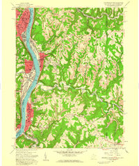 1958 Steubenville East1959 Print · USGSSteubenville and the Ohio River valley are shown in detail during the late fifties as industrial growth climbed the surrounding bluffs. Researchers can trace local landmarks like the College of Steubenville, Mingo Cem, and the rail lines through Colliers.2 unique versions available
 - 1958 Map of Knoxville, 1960 Print
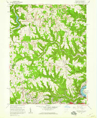 1958 Knoxville1960 Print · USGSJefferson County was undergoing a mid-century shift toward suburban growth and industrial extraction in the late fifties. Genealogists and local historians can trace family-named sites like Shelley Cem and Norton Hill, alongside landmarks like Jefferson Union Sch and the Toronto Airport.2 unique versions available
 - 1958 Map of Weirton, 1960 Print
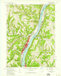
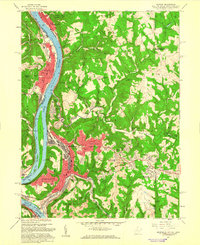 1958 Weirton1960 Print · USGSWeirton and the surrounding Ohio River valley are shown here during a decade of significant post-war growth. Researchers can trace family history through numerous labeled schools and landmarks like Holidays Cove and Three Springs Cem.2 unique versions available
 - 1959 Map of Bethany, 1961 Print
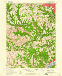
 1959 Bethany1961 Print · USGSIn the late fifties, the northern panhandle of West Virginia remained a landscape of steep ridges, coal mines, and historic college towns. Genealogists and researchers can trace family landmarks like the Alexander Campbell Mansion, Morgan Cem, and Stone Chapel Ch.3 unique versions available
End of results
Showing maps 1-9 of 9
Frequently asked questions
- What are the different types of historical maps available for Brooke County?
- What is the oldest map of Brooke County?
- Where can I purchase historical maps of Brooke County for my home or office?
- Where can I download high-res historical maps of Brooke County?
- Are there historical topographic maps available for Brooke County?
- Is there historical aerial imagery available for Brooke County?
- Where are historical maps of Brooke County sourced from?