1900-1909 Maps of Oka, West Virginia
Explore 2 historic maps of Oka from 1900-1909. These maps offer a rare glimpse into what life looked like during the 1900s — showing old roads, neighborhoods, homes, and landmarks that have changed or disappeared over time.
Whether you're researching your family's past, planning a metal detecting trip, or studying how Oka's landscape evolved across the 1900s, these high-resolution maps are a powerful tool for exploring the history of this region.
- Focus on a specific era: All maps on this page are from the 1900s, giving you a focused view of this time period.
- See what’s changed: Compare century-old streets, trails, and buildings to today's modern landscape using overlays and satellite layers.
- Research with precision: Use these maps for genealogy, historical research, land use analysis, or educational projects.
- View, download, or print: Maps are fully viewable online in high resolution, and can be downloaded or printed for your own records.
Start exploring Oka's history through authentic maps from the 1900s. This is your window into the past.
Oka, WV maps
(2)- 1906 Map of Otter, 1961 Print
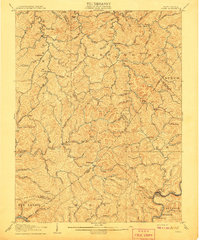
 1906 Otter1961 Print · USGSCentral West Virginia at the start of the twentieth century shows a landscape of deep hollows and high ridges before modern highways. Researchers can trace early settlements and family homesteads near Ivydale, Newton, and the remote Redhouse Siding along the Elk River.
 - 1907 Map of Otter
 1907 Otter1907 Print · USGSCentral West Virginia at the turn of the century shows a landscape defined by its river valleys and new industrial rails. Genealogists can trace family homes near Newton, Linden, and Minnora, or follow the path of the Coal and Coke R R through Ivydale.3 unique versions available
End of results
Showing maps 1-2 of 2
Top cities near Oka
Frequently asked questions
- What are the different types of historical maps available for Oka?
- What is the oldest map of Oka?
- Where can I purchase historical maps of Oka for my home or office?
- Where can I download high-res historical maps of Oka?
- Are there historical topographic maps available for Oka?
- Is there historical aerial imagery available for Oka?
- Where are historical maps of Oka sourced from?