1910s Maps of Meadow Bridge, West Virginia
Explore 2 historic maps of Meadow Bridge from the 1910s. These maps offer a rare glimpse into what life looked like during the 1910s — showing old roads, neighborhoods, homes, and landmarks that have changed or disappeared over time.
Whether you're researching your family's past, planning a metal detecting trip, or studying how Meadow Bridge's landscape evolved across the 1910s, these high-resolution maps are a powerful tool for exploring the history of this region.
- Focus on a specific era: All maps on this page are from the 1910s, giving you a focused view of this time period.
- See what’s changed: Compare century-old streets, trails, and buildings to today's modern landscape using overlays and satellite layers.
- Research with precision: Use these maps for genealogy, historical research, land use analysis, or educational projects.
- View, download, or print: Maps are fully viewable online in high resolution, and can be downloaded or printed for your own records.
Start exploring Meadow Bridge's history through authentic maps from the 1910s. This is your window into the past.
Meadow Bridge, WV maps
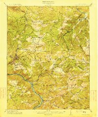
(2)- 1912 Map of Meadow Creek
 1912 Meadow Creek1912 Print · USGSWest Virginia's Fayette and Greenbrier borderlands are captured here in the early twentieth century, showing a landscape of timber and mountain settlements. Genealogists can locate dozens of country schools like Rock of Ages School and Eureka School, alongside the Sandstone Falls on the New River.3 unique versions available
 - 1915 Map of Meadow Creek
 1915 Meadow Creek1915 Print · USGSThe West Virginia highlands come to life in this detailed survey of the mountain ridges and river valleys just before the First World War. Genealogists can locate dozens of country schools and remote post offices like Rock of Ages School, Brownwood Lawton P.O., and Layland.3 unique versions available
End of results
Showing maps 1-2 of 2
Top cities near Meadow Bridge
- Oak Hill historical maps
- Hinton historical maps
- Rainelle historical maps
- Rupert historical maps
- Quinwood historical maps
- Thurmond historical maps
Frequently asked questions
- What are the different types of historical maps available for Meadow Bridge?
- What is the oldest map of Meadow Bridge?
- Where can I purchase historical maps of Meadow Bridge for my home or office?
- Where can I download high-res historical maps of Meadow Bridge?
- Are there historical topographic maps available for Meadow Bridge?
- Is there historical aerial imagery available for Meadow Bridge?
- Where are historical maps of Meadow Bridge sourced from?