1960s Maps of Hereford, West Virginia
Explore 2 historic maps of Hereford from the 1960s. These maps offer a rare glimpse into what life looked like during the 1960s — showing old roads, neighborhoods, homes, and landmarks that have changed or disappeared over time.
Whether you're researching your family's past, planning a metal detecting trip, or studying how Hereford's landscape evolved across the 1960s, these high-resolution maps are a powerful tool for exploring the history of this region.
- Focus on a specific era: All maps on this page are from the 1960s, giving you a focused view of this time period.
- See what’s changed: Compare century-old streets, trails, and buildings to today's modern landscape using overlays and satellite layers.
- Research with precision: Use these maps for genealogy, historical research, land use analysis, or educational projects.
- View, download, or print: Maps are fully viewable online in high resolution, and can be downloaded or printed for your own records.
Start exploring Hereford's history through authentic maps from the 1960s. This is your window into the past.
Hereford, WV maps
(2)- 1960 Map of Gay, 1963 Print
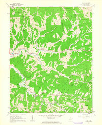 1960 Gay1963 Print · USGSJackson County hill country in the early sixties was a landscape of deep hollows and high knobs connected by narrow valley roads. Genealogists can trace family roots at Waybright Cem, Evans Cem, and the small community of Gay.3 unique versions available
 - 1961 Map of Charleston
 1961 Charleston1961 Print · USGSWest Virginia's capital region and the highlands to the east are shown in detail during the early sixties. Genealogists and historians can trace rail networks like the Baltimore and Ohio RR and find early state parks such as Watoga State Park.
End of results
Showing maps 1-2 of 2
Top cities near Hereford
Frequently asked questions
- What are the different types of historical maps available for Hereford?
- What is the oldest map of Hereford?
- Where can I purchase historical maps of Hereford for my home or office?
- Where can I download high-res historical maps of Hereford?
- Are there historical topographic maps available for Hereford?
- Is there historical aerial imagery available for Hereford?
- Where are historical maps of Hereford sourced from?