1960s Maps of Black Bottom, West Virginia
Explore 2 historic maps of Black Bottom from the 1960s. These maps offer a rare glimpse into what life looked like during the 1960s — showing old roads, neighborhoods, homes, and landmarks that have changed or disappeared over time.
Whether you're researching your family's past, planning a metal detecting trip, or studying how Black Bottom's landscape evolved across the 1960s, these high-resolution maps are a powerful tool for exploring the history of this region.
- Focus on a specific era: All maps on this page are from the 1960s, giving you a focused view of this time period.
- See what’s changed: Compare century-old streets, trails, and buildings to today's modern landscape using overlays and satellite layers.
- Research with precision: Use these maps for genealogy, historical research, land use analysis, or educational projects.
- View, download, or print: Maps are fully viewable online in high resolution, and can be downloaded or printed for your own records.
Start exploring Black Bottom's history through authentic maps from the 1960s. This is your window into the past.
Black Bottom, WV maps
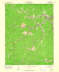
(2)- 1960 Map of Jenkins
 1960 Jenkins1960 Print · USGSEastern Kentucky and the West Virginia borderlands are captured at a mid-century peak of the coal and rail era. Trace the industrial corridors of the Chesapeake and Ohio RR through mountain hubs like Hazard and Jenkins.
 - 1963 Map of Holden, 1964 Print
 1963 Holden1964 Print · USGSMid-century Logan County coal country is meticulously documented here as industry and community life centered on the narrow valleys. Genealogists and historians can locate family cemeteries such as Mounts Cemetery, local schools like Whitman School, and several churches including Number 21 Ch.3 unique versions available
End of results
Showing maps 1-2 of 2
Top cities near Black Bottom
- Madison historical maps
- Mallory historical maps
- Logan historical maps
- Chapmanville historical maps
- Holden historical maps
- Man historical maps
See more
Frequently asked questions
- What are the different types of historical maps available for Black Bottom?
- What is the oldest map of Black Bottom?
- Where can I purchase historical maps of Black Bottom for my home or office?
- Where can I download high-res historical maps of Black Bottom?
- Are there historical topographic maps available for Black Bottom?
- Is there historical aerial imagery available for Black Bottom?
- Where are historical maps of Black Bottom sourced from?