1960s Maps of Sarah Ann, West Virginia
Explore 2 historic maps of Sarah Ann from the 1960s. These maps offer a rare glimpse into what life looked like during the 1960s — showing old roads, neighborhoods, homes, and landmarks that have changed or disappeared over time.
Whether you're researching your family's past, planning a metal detecting trip, or studying how Sarah Ann's landscape evolved across the 1960s, these high-resolution maps are a powerful tool for exploring the history of this region.
- Focus on a specific era: All maps on this page are from the 1960s, giving you a focused view of this time period.
- See what’s changed: Compare century-old streets, trails, and buildings to today's modern landscape using overlays and satellite layers.
- Research with precision: Use these maps for genealogy, historical research, land use analysis, or educational projects.
- View, download, or print: Maps are fully viewable online in high resolution, and can be downloaded or printed for your own records.
Start exploring Sarah Ann's history through authentic maps from the 1960s. This is your window into the past.
Sarah Ann, WV maps
(2)- 1961 Map of Bluefield
 1961 Bluefield1961 Print · USGSThe coalfields and mountain ridges of southern West Virginia and southwest Virginia are captured in the early sixties. Genealogists can trace family ties through rail-linked towns like Princeton and Richlands or along the shores of Bluestone Reservoir.
 - 1963 Map of Man, 1965 Print
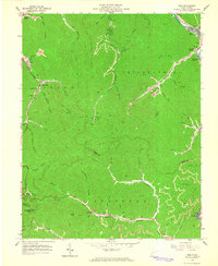 1963 Man1965 Print · USGSThe coal country of Logan and Mingo Counties is shown here in the early 1960s as industrial hollows and family homesteads line the creeks. Researchers can trace ancestral sites like Hatfield Cem or explore the rail hubs of Man and Stirrat.3 unique versions available
End of results
Showing maps 1-2 of 2
Top cities near Sarah Ann
- Mallory historical maps
- Logan historical maps
- Holden historical maps
- Man historical maps
- Accoville historical maps
- Switzer historical maps
See more
Frequently asked questions
- What are the different types of historical maps available for Sarah Ann?
- What is the oldest map of Sarah Ann?
- Where can I purchase historical maps of Sarah Ann for my home or office?
- Where can I download high-res historical maps of Sarah Ann?
- Are there historical topographic maps available for Sarah Ann?
- Is there historical aerial imagery available for Sarah Ann?
- Where are historical maps of Sarah Ann sourced from?