1950s Maps of Hurricane, West Virginia
Explore 6 historic maps of Hurricane from the 1950s. These maps offer a rare glimpse into what life looked like during the 1950s — showing old roads, neighborhoods, homes, and landmarks that have changed or disappeared over time.
Whether you're researching your family's past, planning a metal detecting trip, or studying how Hurricane's landscape evolved across the 1950s, these high-resolution maps are a powerful tool for exploring the history of this region.
- Focus on a specific era: All maps on this page are from the 1950s, giving you a focused view of this time period.
- See what’s changed: Compare century-old streets, trails, and buildings to today's modern landscape using overlays and satellite layers.
- Research with precision: Use these maps for genealogy, historical research, land use analysis, or educational projects.
- View, download, or print: Maps are fully viewable online in high resolution, and can be downloaded or printed for your own records.
Start exploring Hurricane's history through authentic maps from the 1950s. This is your window into the past.
Hurricane, WV maps
(6)- 1954 Map of Charleston
 1954 Charleston1954 Print · USGSWest Virginia’s industrial heart and mountain highlands are captured here during the mid-fifties, centered on the capital city. Researchers can trace historic river-and-rail corridors along the Kanawha River and locate remote peaks within the Monongahela National Forest.
 - 1957 Map of Huntington, 1966 Print
 1957 Huntington1966 Print · USGSThe industrial heart of the Ohio River valley is captured here in the mid-sixties, showing the growth of Huntington and Ashland. Researchers can trace the extensive rail networks of the Chesapeake and Ohio RR and locate sites like the Chief Cornstalk Hunting Ground.3 unique versions available
 - 1957 Map of Charleston, 1966 Print
 1957 Charleston1966 Print · USGSMid-century West Virginia unfolds along the industrial Kanawha River valley and into the high Allegheny Mountains. Genealogists and historians can trace the vital rail lines of the Chesapeake and Ohio and locate riverside settlements from Saint Albans to Buckhannon.3 unique versions available
 - 1958 Map of Charleston
 1958 Charleston1958 Print · USGSMid-century West Virginia is defined here by the industrial corridor of the Kanawha River and the high ridges of the Allegheny Mountains. Researchers can trace the rail networks of the New York Central or locate remote highland communities like Pickens and Hillsboro.
 - 1958 Map of Hurricane, 1960 Print
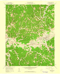 1958 Hurricane1960 Print · USGSThe Teays Valley corridor was maturing in the late fifties as a vital link between Huntington and Charleston. Genealogists and historians can trace the foundations of local life through the Morris Memorial Hospital, Lake Washington, and numerous rural institutions like Providence Ch.
 - 1958 Map of Scott Depot, 1960 Print
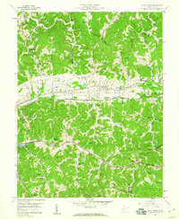 1958 Scott Depot1960 Print · USGSIn the late fifties, the historic Teays Valley served as a vital transportation corridor for the Chesapeake and Ohio railroad. Genealogists and local historians can locate several rural schools and churches, such as Big Scary Sch, Scott Teays Sch, and Providence Ch.4 unique versions available
End of results
Showing maps 1-6 of 6
Top cities near Hurricane
- Teays Valley historical maps
- St. Albans historical maps
- Saint Albans historical maps
- Culloden historical maps
- Milton historical maps
- Winfield historical maps
See more
Top neighborhoods of Hurricane
Frequently asked questions
- What are the different types of historical maps available for Hurricane?
- What is the oldest map of Hurricane?
- Where can I purchase historical maps of Hurricane for my home or office?
- Where can I download high-res historical maps of Hurricane?
- Are there historical topographic maps available for Hurricane?
- Is there historical aerial imagery available for Hurricane?
- Where are historical maps of Hurricane sourced from?