1970s Maps of Hewlet, West Virginia
Explore 1 historic maps of Hewlet from the 1970s. These maps offer a rare glimpse into what life looked like during the 1970s — showing old roads, neighborhoods, homes, and landmarks that have changed or disappeared over time.
Whether you're researching your family's past, planning a metal detecting trip, or studying how Hewlet's landscape evolved across the 1970s, these high-resolution maps are a powerful tool for exploring the history of this region.
- Focus on a specific era: All maps on this page are from the 1970s, giving you a focused view of this time period.
- See what’s changed: Compare century-old streets, trails, and buildings to today's modern landscape using overlays and satellite layers.
- Research with precision: Use these maps for genealogy, historical research, land use analysis, or educational projects.
- View, download, or print: Maps are fully viewable online in high resolution, and can be downloaded or printed for your own records.
Start exploring Hewlet's history through authentic maps from the 1970s. This is your window into the past.
Hewlet, WV maps
(1)- 1971 Map of Fallsburg, 1973 Print
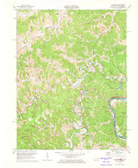 1971 Fallsburg1973 Print · USGSIn the early 1970s, the rugged borderlands of Lawrence County were a complex network of rail lines and creek-side settlements. Researchers can trace the legacy of family homesteads and industry through labels for the Covered Bridge, Garrett Chapel, and the coal-and-oil works of the Big Sandy River valley.4 unique versions available
End of results
Showing maps 1-1 of 1
Top cities near Hewlet
- Huntington historical maps
- Kenova historical maps
- Louisa historical maps
- Ceredo historical maps
- Wayne historical maps
- Fort Gay historical maps
See more
Frequently asked questions
- What are the different types of historical maps available for Hewlet?
- What is the oldest map of Hewlet?
- Where can I purchase historical maps of Hewlet for my home or office?
- Where can I download high-res historical maps of Hewlet?
- Are there historical topographic maps available for Hewlet?
- Is there historical aerial imagery available for Hewlet?
- Where are historical maps of Hewlet sourced from?