Old Maps of Doyle, Wisconsin for Genealogy
Trace your family roots with 16 historic maps of Doyle. These high-res maps reveal old neighborhoods, homesites, landmarks, and streets — helping you uncover where your ancestors lived and how the area evolved over time.
- Explore historic neighborhoods: Identify where your relatives may have lived in the 1800s or 1900s.
- Compare maps over time: Trace the changes in streets, buildings, and landmarks for multi-generational research.
- Perfect for genealogy & ancestry research: Used by family historians and researchers to map out lineage and migration.
These maps are an incredible resource for exploring your personal connection to Doyle's past.
Doyle, WI maps
(16)- 1949 Map of Rice Lake, 1961 Print
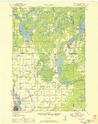
 1949 Rice Lake1961 Print · USGSIn the Wisconsin Northwoods after the war, the lakeside communities and rural schools of Barron and Washburn counties remained tightly knit. Genealogists can find family landmarks like Loveland Corners, Evergreen Ch, and the many rural schools including Lincoln Sch.
 - 1951 Map of Rice Lake
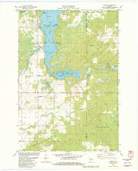
 1951 Rice Lake1951 Print · USGSNorthwest Wisconsin’s lake country is captured in the early fifties, showing the transition from rail-dependent commerce to modern aviation. Researchers can trace dozens of country schoolhouses like Pioneer Sch and Lincoln Sch, or locate the Rice Lake Municipal Airport.
 - 1951 Map of Chetek, 1953 Print
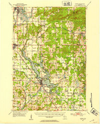 1951 Chetek1953 Print · USGSThe Chetek region in the early fifties shows a landscape of interconnected glacial lakes and growing rail towns. Trace the history of rural education and transport through local landmarks like Edgewood Sch and the CHICAGO AND NORTH WESTERN railroad.2 unique versions available
 - 1953 Map of Rice Lake, 1967 Print
 1953 Rice Lake1967 Print · USGSNorthwest Wisconsin during the mid-fifties reveals a landscape defined by timber, rail, and water. Genealogists and historians can trace the development of river towns like Ladysmith and Rice Lake along the Soo Line and Chicago and North Western railroads.2 unique versions available
 - 1959 Map of Rice Lake
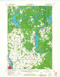
 1959 Rice Lake1959 Print · USGSNorthwest Wisconsin in the late fifties was a land of expanding road networks and deep-seated timber history. Genealogists and historians can trace rail lines like the Soo Line RR and Chicago St Paul Minneapolis and Omaha Ry as they link settlements from Spooner to Medford.
 - 1965 Map of Rice Lake, 1967 Print
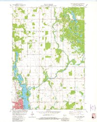
 1965 Rice Lake1967 Print · USGSThe lake country of Barron and Washburn counties is shown here in the mid-1960s, a landscape of interconnected waterways and rural townships. Genealogists and local historians can trace legacy sites like the Oak Grove Center Sch, Evergreen Cem, and the settlement at Mikana.
 - 1978 Map of Rice Lake South, 1979 Print
 1978 Rice Lake South1979 Print · USGSBarron County in the late seventies shows a landscape of lakefront growth and rural tradition centered on the Rice Lake corridor. Genealogists and local historians can trace family sites at St Joseph Cemetery or the Pioneer Rest Cemetery, and locate vanished landmarks like the Drive-in Theater.
 - 1978 Map of Strickland, 1979 Print
 1978 Strickland1979 Print · USGSBarron and Rusk counties were defined by heavy timber and glacial lakes in the late seventies. Family historians can trace the Soo Line rail corridor through old stops at Lehigh and Strickland, or locate family landmarks near Perdziak Lake.
 - 1980 Map of Spooner
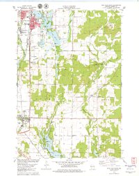
 1980 Spooner1980 Print · USGSNorthwestern Wisconsin at the dawn of the eighties reveals a landscape of deep forests and transitioning rail corridors. Genealogists and historians can trace lakefront settlements like Spooner and Birchwood or follow the early Tuscobia-Park Falls State Trail.
 - 1980 Map of Bloomer
 1980 Bloomer1980 Print · USGSNorthwestern Wisconsin at the start of the eighties shows a landscape deeply connected to its rivers and rail lines. Genealogists and historians can trace the growth of Bloomer, Ladysmith, and Chetek or locate local landmarks like Brunet Island State Park and the Soo Line rail corridors.
 - 1981 Map of Rice Lake North, 1982 Print
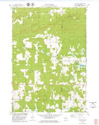
 1981 Rice Lake North1982 Print · USGSBarron County in the early eighties shows a transition from a rail-centered economy to a recreation-focused landscape. Genealogists and local historians can locate Nora Cem, the Indian Mound Park, and the historic tracks of the Chicago and North Western.
 - 1981 Map of Mikana, 1982 Print
 1981 Mikana1982 Print · USGSBarron County's lake district is documented here in the early eighties as rail corridors transitioned into recreational trails. Genealogists and local researchers can locate Mikana, the Immanuel Ch, and family-named landmarks like Stout Island.
 - 2022 Map of Rice Lake North, 2022 Print
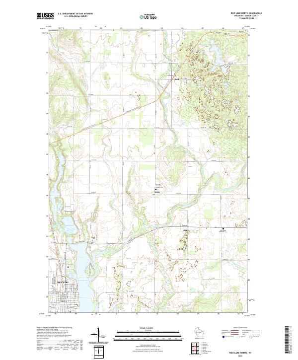 2022 Rice Lake North2022 Print · USGSNorthern Barron County remains a landscape of glacial lakes and river junctions as seen in this contemporary survey. Genealogists and local historians can trace the rural communities of Dobie and Campia or locate family plots at Nora Cemetery and Our Saviors Lutheran Cemetery.
 - 2022 Map of Rice Lake South, 2022 Print
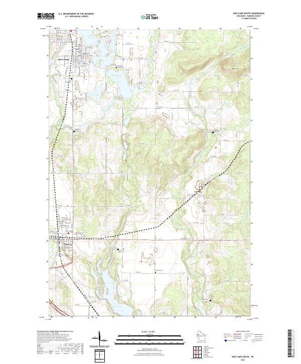 2022 Rice Lake South2022 Print · USGSBarron County in the early twenty-first century reveals a landscape defined by the Red Cedar River and glacial lakes. Family historians can locate numerous burial sites across the township, including Pine Grove Cem, Faaberg Cem, and Old Sumner Cem.
 - 2022 Map of Mikana, 2022 Print
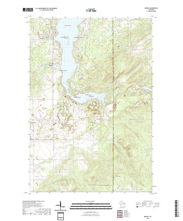 2022 Mikana2022 Print · USGSRed Cedar Lake and its many islands define this pocket of northern Wisconsin in the early twenty-first century. Genealogists and hikers can trace the Ice Age National Scenic Trail past the Blue Hills or locate family roots near Mikana and Cedar Lake Cemetery.
 - 2022 Map of Strickland, 2022 Print
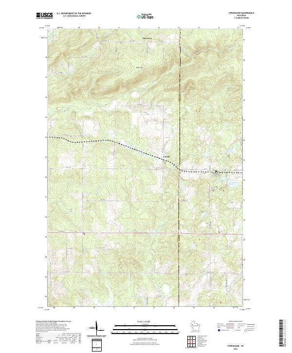 2022 Strickland2022 Print · USGSNorthwestern Wisconsin’s wooded uplands and glacial lakes are shown here in recent detail, capturing the quiet character of the Barron and Rusk county line. Researchers can locate the Assumption of the Blessed Virgin Mary Cem and trace the paths of Moose Ear Cr near the settlements of Lehigh and Horseman.
End of results
Showing maps 1-16 of 16
Top cities near Doyle
- Rice Lake historical maps
- Barron historical maps
- Chetek historical maps
- Cameron historical maps
- Beaver Brook historical maps
- Sumner historical maps
See more
Top neighborhoods of Doyle
Frequently asked questions
- What are the different types of historical maps available for Doyle?
- What is the oldest map of Doyle?
- Where can I purchase historical maps of Doyle for my home or office?
- Where can I download high-res historical maps of Doyle?
- Are there historical topographic maps available for Doyle?
- Is there historical aerial imagery available for Doyle?
- Where are historical maps of Doyle sourced from?