Old Maps of Woodland Corner, Blaine for Academic Research
Study the evolution of Woodland Corner with 7 high-resolution historic maps. Whether you're teaching, researching, or modeling changes in land use, these maps provide essential visual documentation of urban, environmental, and geographic change.
- Analyze long-term change: Track patterns in development, transportation, and natural features.
- Ideal for environmental or urban studies: Support academic projects with primary historical map data.
- Use in the classroom or lab: Educators and researchers rely on these maps to bring historical context to life.
These maps are a powerful tool for teaching, research, and visualizing how Woodland Corner has changed over the decades.
Woodland Corner, Blaine maps
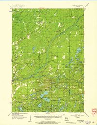
(7)- 1949 Map of Webb Lake
 1949 Webb Lake1949 Print · USGSNorthwest Wisconsin’s lake country is captured here in the late 1940s as rural life centered on the St Croix River. Researchers can trace old crossroads and remote outposts like Dairyland, Cozy Corners, and the historic Webb Lake Sch.
 - 1953 Map of Duluth, 1964 Print
 1953 Duluth1964 Print · USGSNortheastern Minnesota and northwestern Wisconsin are shown here during a period of industrial maturity and expanding conservation. Genealogists and historians can trace rail-connected towns like McGrath and Wahkon, or locate heritage sites within the Fond du Lac Indian Reservation.2 unique versions available
 - 1955 Map of Webb Lake, 1957 Print
 1955 Webb Lake1957 Print · USGSNorthwestern Wisconsin’s lake country is captured here in the mid-fifties, showing the confluence of the St. Croix and Namekagon rivers. Researchers can trace rural life through sites like Cozy Corner, the Webb Lake Sch, and the Dairyland Lookout Tower.2 unique versions available
 - 1958 Map of Duluth
 1958 Duluth1958 Print · USGSNortheastern Minnesota and the Wisconsin borderlands are shown in detail during the late 1950s, centered on the bustling rail yards and ports of Duluth. You can trace the historic routes of the Soo Line and Duluth Missabe & Iron Range through small towns like McGrath, Bruno, and Wrenshall.
 - 1980 Map of Sandstone
 1980 Sandstone1980 Print · USGSPine County and the Minnesota-Wisconsin borderlands are shown here in the early eighties as a region of dense state forests and river corridors. Genealogists and historians can trace rail-town development along the Burlington Northern including Sandstone, Askov, and Hinckley.
 - 1983 Map of Dairyland
 1983 Dairyland1983 Print · USGSNorthwestern Wisconsin at the Douglas and Burnett county line comes into focus in the early eighties. Genealogists and local historians can trace the rural landscape of Kingsdale and Cozy Corner, or locate family sites near Covenant Ch and the Dairyland Cem.
 - 2022 Map of Dairyland, 2022 Print
 2022 Dairyland2022 Print · USGSDouglas County's southern timberlands and the upper reaches of the St. Croix valley are mapped here in the early 2020s. Genealogists can locate Dairyland Cem while outdoor researchers trace McGraw Lake and the Saint Croix National Scenic Riverway.
End of results
Showing maps 1-7 of 7
Top cities near Woodland Corner
- Gordon historical maps
- Wascott historical maps
- Webb Lake historical maps
- Dairyland historical maps
- Kingsdale historical maps
Frequently asked questions
- What are the different types of historical maps available for Woodland Corner?
- What is the oldest map of Woodland Corner?
- Where can I purchase historical maps of Woodland Corner for my home or office?
- Where can I download high-res historical maps of Woodland Corner?
- Are there historical topographic maps available for Woodland Corner?
- Is there historical aerial imagery available for Woodland Corner?
- Where are historical maps of Woodland Corner sourced from?