1960s Maps of Perry, Wisconsin
Explore 7 historic maps of Perry from the 1960s. These maps offer a rare glimpse into what life looked like during the 1960s — showing old roads, neighborhoods, homes, and landmarks that have changed or disappeared over time.
Whether you're researching your family's past, planning a metal detecting trip, or studying how Perry's landscape evolved across the 1960s, these high-resolution maps are a powerful tool for exploring the history of this region.
- Focus on a specific era: All maps on this page are from the 1960s, giving you a focused view of this time period.
- See what’s changed: Compare century-old streets, trails, and buildings to today's modern landscape using overlays and satellite layers.
- Research with precision: Use these maps for genealogy, historical research, land use analysis, or educational projects.
- View, download, or print: Maps are fully viewable online in high resolution, and can be downloaded or printed for your own records.
Start exploring Perry's history through authentic maps from the 1960s. This is your window into the past.
Perry, WI maps
(7)- 1962 Map of New Glarus, 1964 Print
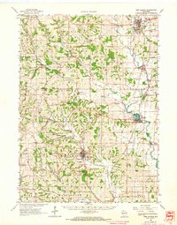 1962 New Glarus1964 Print · USGSSouthern Wisconsin's driftless terrain and Swiss-settled valleys are captured here in the early sixties, showing the rural character of Green and Dane Counties. Researchers can trace family history through sites like East Blue Mounds Church, Oak Hill Cem, and the Andrew Henry School.2 unique versions available
 - 1962 Map of Blanchardville, 1964 Print
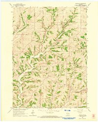
 1962 Blanchardville1964 Print · USGSSouthern Wisconsin's rolling uplands and river valleys are captured here in the early sixties, showing the vital rail-and-river connection at Blanchardville. Researchers can trace rural life through dozens of local landmarks like the Moscow Center School, Yellowstone Church, and the newly created Yellowstone Lake.
 - 1962 Map of Mt. Vernon, 1964 Print
 1962 Mt. Vernon1964 Print · USGSDane County's rolling driftless terrain is captured here in the early sixties as a network of small dairy-farming communities. Researchers can trace rural school locations like Britt Valley Sch or find family history at Primrose Ch and Mt Vernon Cem.2 unique versions available
 - 1962 Map of Daleyville, 1964 Print
 1962 Daleyville1964 Print · USGSWisconsin's rural dairy country in the early sixties is captured here along the border of Iowa and Dane counties. Genealogists can trace family footprints through a dense network of country schools and churches, including Ruste Sch, Hauge Ch, and Forward Sch.
 - 1962 Map of New Glarus, 1964 Print
 1962 New Glarus1964 Print · USGSNew Glarus and the surrounding driftless-area townships appear here in the early sixties, showing the village's grid and the area's many quarries. Researchers can locate the Swiss Cem, follow the Little Sugar River, or explore Pioneer Valley.
 - 1962 Map of Blanchardville, 1964 Print
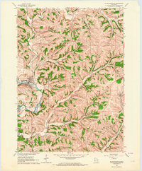 1962 Blanchardville1964 Print · USGSBlanchardville and the surrounding Driftless Area valleys are captured here in the early sixties as a bustling center of river and rail commerce. Researchers can locate family landmarks like the York Memorial Ch Cem, Meadowview School, and the scattered Quarries of the York township.
 - 1963 Map of Rockford
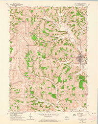
 1963 Rockford1963 Print · USGSThe mid-century industrial corridor along the Rock River is shown here during a period of rapid post-war growth. Researchers can trace the extensive rail lines of the Chicago and North Western or locate local landmarks like the Rockford Ordnance Depot and Holy Hill.
End of results
Showing maps 1-7 of 7
Top cities near Perry
- Madison historical maps
- Middleton historical maps
- Verona historical maps
- Mount Horeb historical maps
- Cross Plains historical maps
- Belleville historical maps
See more
Top neighborhoods of Perry
Frequently asked questions
- What are the different types of historical maps available for Perry?
- What is the oldest map of Perry?
- Where can I purchase historical maps of Perry for my home or office?
- Where can I download high-res historical maps of Perry?
- Are there historical topographic maps available for Perry?
- Is there historical aerial imagery available for Perry?
- Where are historical maps of Perry sourced from?