Old Maps of Eau Claire Acres, Gordon for Genealogy
Trace your family roots with 8 historic maps of Eau Claire Acres. These high-res maps reveal old neighborhoods, homesites, landmarks, and streets — helping you uncover where your ancestors lived and how the area evolved over time.
- Explore historic neighborhoods: Identify where your relatives may have lived in the 1800s or 1900s.
- Compare maps over time: Trace the changes in streets, buildings, and landmarks for multi-generational research.
- Perfect for genealogy & ancestry research: Used by family historians and researchers to map out lineage and migration.
These maps are an incredible resource for exploring your personal connection to Eau Claire Acres's past.
Eau Claire Acres, Gordon maps
(8)- 1945 Map of Highland, 1956 Print
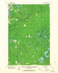
 1945 Highland1956 Print · USGSNorthwestern Wisconsin at the end of the war is revealed here through its intricate network of glacial lakes and northern forests. Researchers can pinpoint mid-century local landmarks like the Frances Willard Sch, Barnes Cem, and the path of the Brule River.
 - 1949 Map of Highland
 1949 Highland1949 Print · USGSDouglas County’s lake-strewn interior is captured here just after the war, showing a landscape defined by glacial waters and forestry. Genealogists can locate rural landmarks like the Frances Willard Sch, Barnes Cem, and the Barnes Town Hall.
 - 1953 Map of Ashland, 1964 Print
 1953 Ashland1964 Print · USGSNorthern Wisconsin's lakefront and timberlands are seen here in the mid-1950s, showing the intersection of industrial rail lines and vast wilderness. Genealogists and historians can trace the Soo Line through rail towns like Mellen or locate family roots in the Apostle Islands and Bad River Indian Reservation.3 unique versions available
 - 1958 Map of Ashland
 1958 Ashland1958 Print · USGSCoastal Wisconsin and the Michigan borderlands meet here in the late fifties, dominated by the timbered expanses and iron-rich ranges. Genealogists can trace family footprints in settlements like Odanah and Montreal, or locate landmarks such as the Coast Guard Station and Agricultural Experiment Station.
 - 1961 Map of Ellison Lake, 1963 Print
 1961 Ellison Lake1963 Print · USGSNorthern Wisconsin's lake country is captured in the early sixties as a center for conservation and recreation. Researchers can trace family history at the Barnes Cem or explore the wilderness around the Bois Brule River and Lake Nebagamon.2 unique versions available
 - 1980 Map of Solon Springs
 1980 Solon Springs1980 Print · USGSNorthern Wisconsin in the early eighties was a landscape of dense timber and sprawling glacial waters. Trace the legacy of the Chicago and North Western rail line through Solon Springs, Hayward, and Minong at this pivotal moment.
 - 1984 Map of Ellison Lake
 1984 Ellison Lake1984 Print · USGSIn the mid-1980s, this portion of Douglas and Bayfield counties shows a dense network of water bodies and local township life. Researchers can trace family history at Barnes Cem or explore early land use near Mooney Dam County Park and the Lookout Tower.
 - 2022 Map of Ellison Lake, 2022 Print
 2022 Ellison Lake2022 Print · USGSGlacial lakes and river systems define this Douglas and Bayfield County borderland in the early twenty-first century. Researchers can trace local landmarks like Barnes Memorial Cem or follow the Eau Claire River between Middle Eau Claire Lake and Lower Eau Claire Lake.
End of results
Showing maps 1-8 of 8
Frequently asked questions
- What are the different types of historical maps available for Eau Claire Acres?
- What is the oldest map of Eau Claire Acres?
- Where can I purchase historical maps of Eau Claire Acres for my home or office?
- Where can I download high-res historical maps of Eau Claire Acres?
- Are there historical topographic maps available for Eau Claire Acres?
- Is there historical aerial imagery available for Eau Claire Acres?
- Where are historical maps of Eau Claire Acres sourced from?