Old Maps of Dunn County, Wisconsin
Explore 186 old maps of Dunn County, spanning from 1929 to today. These high-resolution historic maps reveal how streets, neighborhoods, landmarks, and natural features evolved over time — perfect for genealogy, metal detecting, research, and local history exploration.
What you can do with these maps:
- See how Dunn County changed over time: Compare historical maps to modern-day views to trace roads, homesites, rail lines & more.
- View detailed metadata: Each map includes creators, publishers, year, scale, and archive source.
- Overlay maps with satellite & LiDAR: Visualize the past alongside modern tools to explore terrain & human change.
- Trusted historical sources: Maps sourced from the USGS, Library of Congress, and other archives.
- Access maps your way: View online, download high-res files, or order prints for personal or research use.
Start exploring old maps of Dunn County to uncover forgotten places, hidden landmarks, and the deep history beneath your feet.
Dunn County, WI maps
(186)- 1929 Map of Durand, 1970 Print
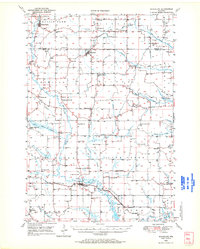
 1929 Durand1970 Print · USGSThe Chippewa River valley in the late 1920s reveals a landscape of river-bottom settlements and upland family farms. Genealogists can trace rural roots through numerous schoolhouses like Woods Corner Sch and landmarks like the Meridean Ferry.
 - 1932 Map of Durand
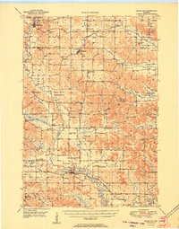
 1932 Durand1932 Print · USGSThe Chippewa River valley in the early 1930s is a landscape of complex waterways and bustling rural districts. Genealogists and historians can locate dozens of country schools like Luna Sch and trace the old rail lines serving Durand and Dunnville.2 unique versions available
 - 1932 Map of Mondovi
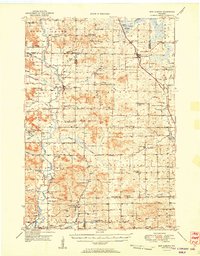
 1932 Mondovi1932 Print · USGSThe Buffalo River valley and surrounding coulees are shown here in the early thirties, centered on the hub of Mondovi. Genealogists can locate dozens of country schoolhouses like White Block Sch and rural landmarks such as Norden Ch.2 unique versions available
 - 1934 Map of Elk Mound, 1960 Print
 1934 Elk Mound1960 Print · USGSDunn and Eau Claire counties come alive in this mid-thirties survey, showing the intricate network of rural schools and the bustling rail corridor through Elk Mound. Genealogists can trace family roots at Porters Mills, Big Elk Creek Ch, or numerous local school sites like Waneka Sch.2 unique versions available
 - 1935 Map of Arkansaw
 1935 Arkansaw1935 Print · USGSThe rural uplands and river valleys of Pepin and Dunn Counties are captured here during the mid-1930s. Researchers can trace dozens of country school sites like Point Sch and Knight Sch, or locate family landmarks at Exile and Eau Galle Mill.
 - 1936 Map of Elk Mound
 1936 Elk Mound1936 Print · USGSDunn and Eau Claire Counties in the mid-thirties show a landscape of thriving rural school districts and river-bound commerce. Genealogists can trace family landmarks like The Yankee Woods or locate vanished sites like Porters Mills and the Old Meridean Ferry.2 unique versions available
 - 1940 Map of Menomonie, 1965 Print
 1940 Menomonie1965 Print · USGSDunn County in the early 1940s is a landscape of established river towns and a dense network of country schoolhouses. Genealogists can trace family roots through sites like Beyer Settlement Sch, Ideal Cem, and the County Asylum.2 unique versions available
 - 1941 Map of Arkansaw
 1941 Arkansaw1941 Print · USGSPepin and Pierce counties appear at the start of the 1940s as a land of rural schools and river-valley farming. Researchers can trace family sites at Plum City, Dead Lake Cem, or schools like Maxwell Prairie Sch along the Chippewa River.
 - 1942 Map of Arkansaw
 1942 Arkansaw1942 Print · USGSThe Driftless Area of Pepin and Pierce counties comes to life in the 1940s, showing a landscape of deep coulees and river valleys. Genealogists can locate dozens of country schools like Whipple Hill Sch and historic local landmarks such as St Joseph Ch and Exile.2 unique versions available
 - 1942 Map of Menomonie
 1942 Menomonie1942 Print · USGSDunn County at the start of the 1940s reveals a region of thriving river towns and closely knit rural school districts. Genealogists can trace family roots through numerous country schools like Knapp Settlement School and local burial grounds such as Sherman Cem.
 - 1946 Map of Knapp, 1967 Print
 1946 Knapp1967 Print · USGSThe borderlands of St. Croix, Pierce, and Dunn Counties come to life in this mid-century survey of the Wisconsin dairy country. Genealogists can locate dozens of country schools like Broadview Sch and Denver Sch, as well as the Dunkard Ch and Teegarden Cem.
 - 1948 Map of Downing, 1970 Print
 1948 Downing1970 Print · USGSWestern Wisconsin's agricultural and rail heartland is captured here in the late 1940s, centered on the villages of the Tiffany Creek valley. Genealogists can trace family roots through dozens of rural landmarks like Beaver Valley Sch, Graytown, and Immanuel Ch.
 - 1949 Map of Knapp
 1949 Knapp1949 Print · USGSDunn, St. Croix, and Pierce counties come together in the late 1940s, showing a landscape defined by small-scale farming and the rail corridor. Genealogists can locate dozens of country schools and churches like Wilson Ch, East Hill Sch, and Hatchville Ch.
 - 1949 Map of New Auburn, 1967 Print
 1949 New Auburn1967 Print · USGSWisconsin's rural dairy and timber heartland is meticulously documented here just after the war, showing the tight-knit settlement of western Chippewa County. Genealogists can trace family roots through numerous local landmarks like Fox Settlement, Lower Lutheran Ch, and New Auburn Cem.
 - 1949 Map of Ridgeland, 1970 Print
 1949 Ridgeland1970 Print · USGSThe rural borderlands of Barron and Dunn counties are captured here in the late 1940s, when small-town rail hubs and country schoolhouses still dotted the landscape. Researchers can trace family roots through numerous sites like Evergreen Cem, Vanceburg, and Parkman Sch.
 - 1950 Map of Downing
 1950 Downing1950 Print · USGSWisconsin's dairy and timber heartland is captured here just after the war, centered on the rail-linked towns of Glenwood City and Boyceville. Genealogists can trace family roots through numerous country schools like Peaceful Valley and local landmarks like Chimney Rock.
 - 1951 Map of Ridgeland
 1951 Ridgeland1951 Print · USGSDunn and Barron counties thrive as a network of small-town centers and rural school districts during the early fifties. Genealogists can trace family roots through numerous sites like Lutheran Cem, Zion Ch, and the Little Beaver Sch.
 - 1951 Map of New Auburn
 1951 New Auburn1951 Print · USGSThe intersection of Barron, Dunn, and Chippewa counties comes into focus in the early 1950s, showing a landscape thick with local school districts and rural parishes. Genealogists can trace family footprints through dozens of named sites like Fox Settlement Sch, Dovre Ch, and the New Auburn Cem.
 - 1953 Map of Saint Paul, 1964 Print
 1953 Saint Paul1964 Print · USGSThe Twin Cities and the Mississippi River valley are captured here at a mid-century turning point. Trace the early growth of Minneapolis and Saint Paul alongside landmarks like Lake Minnetonka and the St Croix River.4 unique versions available
 - 1953 Map of Eau Claire, 1965 Print
 1953 Eau Claire1965 Print · USGSWest-central Wisconsin in the mid-fifties shows a landscape of river-valley industry and vast wildlife refuges during the transition from rails to modern highways. Genealogists and historians can trace the rail corridors of the Chicago and North Western or locate family-named landmarks like Decorah Mound and Chippewa Island.4 unique versions available
 - 1953 Map of Rice Lake, 1967 Print
 1953 Rice Lake1967 Print · USGSNorthwest Wisconsin during the mid-fifties reveals a landscape defined by timber, rail, and water. Genealogists and historians can trace the development of river towns like Ladysmith and Rice Lake along the Soo Line and Chicago and North Western railroads.2 unique versions available
 - 1953 Map of Stillwater, 1980 Print
 1953 Stillwater1980 Print · USGSThe Twin Cities and the St. Croix Valley are captured in this mid-century survey as the interstate era began to transform the Upper Midwest. Genealogists and historians can trace the rail-and-river geography of Stillwater, locate landmarks in Anoka, or explore the sprawling St Croix State Park.
 - 1955 Map of Stillwater, 1965 Print
 1955 Stillwater1965 Print · USGSThe Upper St. Croix Valley and the growing Twin Cities area are shown here during the mid-fifties, before the interstate era transformed the regional commute. You can trace the lines of the Northern Pacific RR through towns like Rush City or locate the Saint Croix Indian Reservation.
 - 1958 Map of Stillwater
 1958 Stillwater1958 Print · USGSThe Upper Mississippi and St. Croix River valleys appear in the mid-fifties as the Twin Cities expanded north. Genealogists can locate family landmarks like Oak Park Cem, Saint Michael Church, and the Soo Line RR rail corridors.2 unique versions available
 - 1958 Map of Eau Claire
 1958 Eau Claire1958 Print · USGSWestern Wisconsin in the late fifties shows a landscape of growing regional hubs and massive wildlife refuges. Trace the rail lines of the Chicago and North Western between Eau Claire and Marshfield, or explore the terrain around Iron Mound and Lake Wissota.
Showing maps 1-25 of 186
Top cities of Dunn County
- Menomonie historical maps
- Tainter historical maps
- Red Cedar historical maps
- Colfax historical maps
- Elk Mound historical maps
- Boyceville historical maps
See more
Frequently asked questions
- What are the different types of historical maps available for Dunn County?
- What is the oldest map of Dunn County?
- Where can I purchase historical maps of Dunn County for my home or office?
- Where can I download high-res historical maps of Dunn County?
- Are there historical topographic maps available for Dunn County?
- Is there historical aerial imagery available for Dunn County?
- Where are historical maps of Dunn County sourced from?