Old Maps of Johnson, Wisconsin for Metal Detecting
Plan your next treasure hunt with 19 historic maps of Johnson. Find old homesites, ghost towns, trails, and gathering spots that may be lost to time — perfect for identifying promising metal detecting locations.
- Locate forgotten sites: Uncover places like long-lost settlements, abandoned rail lines, or gathering spots.
- Plan better hunts: Use map overlays combined with LiDAR or satellite views to narrow in on historically rich areas.
- Made for detectorists: Thousands of hobbyists use these maps to discover relics, coins, and hidden history.
Use these historic maps to boost your research and find new opportunities beneath the surface of Johnson.
Johnson, WI maps
(19)- 1902 Map of Marathon, 1938 Print
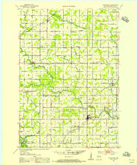
 1902 Marathon1938 Print · USGSMarathon County is captured here at the height of the timber era, when a dense network of logging railroads and new settlements defined the central Wisconsin woods. Genealogists and historians can trace early town sites like Athens, Rib Falls, and the specialized Connors Logging R. R.
 - 1951 Map of Athens, 1954 Print
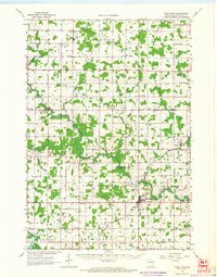
 1951 Athens1954 Print · USGSMarathon and Taylor Counties are captured here in the early fifties, showing a rural landscape organized around the Soo Line railroad. Genealogists can locate dozens of country schools and churches like St Peter Ch, Goodrich Ch, and Corinth Sch.2 unique versions available
 - 1953 Map of Stratford, 1955 Print
 1953 Stratford1955 Print · USGSMarathon County in the early fifties is captured here as a landscape of small dairy farms and rail-connected villages. Genealogists and historians can trace numerous rural landmarks, from Milan and Stratford to family-named schools like Hillcrest Sch and Wescott Sch.
 - 1953 Map of Eau Claire, 1965 Print
 1953 Eau Claire1965 Print · USGSWest-central Wisconsin in the mid-fifties shows a landscape of river-valley industry and vast wildlife refuges during the transition from rails to modern highways. Genealogists and historians can trace the rail corridors of the Chicago and North Western or locate family-named landmarks like Decorah Mound and Chippewa Island.4 unique versions available
 - 1953 Map of Rice Lake, 1967 Print
 1953 Rice Lake1967 Print · USGSNorthwest Wisconsin during the mid-fifties reveals a landscape defined by timber, rail, and water. Genealogists and historians can trace the development of river towns like Ladysmith and Rice Lake along the Soo Line and Chicago and North Western railroads.2 unique versions available
 - 1958 Map of Eau Claire
 1958 Eau Claire1958 Print · USGSWestern Wisconsin in the late fifties shows a landscape of growing regional hubs and massive wildlife refuges. Trace the rail lines of the Chicago and North Western between Eau Claire and Marshfield, or explore the terrain around Iron Mound and Lake Wissota.
 - 1959 Map of Rice Lake
 1959 Rice Lake1959 Print · USGSNorthwest Wisconsin in the late fifties was a land of expanding road networks and deep-seated timber history. Genealogists and historians can trace rail lines like the Soo Line RR and Chicago St Paul Minneapolis and Omaha Ry as they link settlements from Spooner to Medford.
 - 1963 Map of Stratford, 1964 Print
 1963 Stratford1964 Print · USGSMarathon County's rural heartland is captured here in the early sixties, showing the vital intersection of rail and river commerce. Genealogists and historians can trace family locations near Stratford, March Rapids, and several country schools like Strupp Sch.
 - 1964 Map of Eau Claire
 1964 Eau Claire1964 Print · USGSWest-central Wisconsin in the mid-1960s was a hub of river-driven industry and expanding rail networks. Researchers can trace historic homesteads near Menomonie, follow the Soo Line RR through Marshfield, or explore the grounds of the Camp McCoy Military Reservation.
 - 1980 Map of Corinth
 1980 Corinth1980 Print · USGSMarathon and Taylor Counties are shown in the late seventies as a landscape of small townships and river valleys. Genealogists and historians can trace the Corinth settlement, the Old Railroad Grade, and local landmarks like Kreie Sch.
 - 1980 Map of Athens
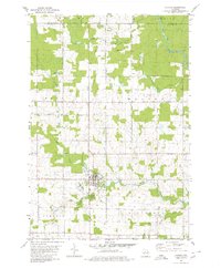 1980 Athens1980 Print · USGSMarathon County at the end of the 1970s shows a landscape of steady agricultural and timber-linked growth centered on the village of Athens. Genealogists and historians can trace the Old Railroad Grade and locate family markers at the local Cem or along Potato Creek.2 unique versions available
 - 1980 Map of Medford
 1980 Medford1980 Print · USGSNorth-central Wisconsin in the early eighties shows a landscape of dense timber and rail-linked settlements. Genealogists and historians can trace the Soo Line through towns like Medford and Westboro or locate family homesteads near Perkinstown and Athens.
 - 1981 Map of Milan, 1982 Print
 1981 Milan1982 Print · USGSMarathon County farmland and river valleys are captured here in the early eighties. Genealogists and local historians can trace family plots at Township Cem and Peace Ch Cem, or locate the rural hubs of Milan and Cherokee.
 - 1982 Map of Wien
 1982 Wien1982 Print · USGSMarathon County dairy country remained a landscape of scattered family farms and tight-knit rural crossroads in the early eighties. Genealogists can trace family roots through the grids of Wuertsburg and Wien, or locate St Johns Ch and the Township Cem.
 - 1984 Map of Marshfield, 1985 Print
 1984 Marshfield1985 Print · USGSCentral Wisconsin's dairy heartland comes into focus during the mid-eighties as a busy network of rail and farm towns. Researchers can trace the path of the Soo Line, identify the grounds of McMillan State Wildlife Area, and locate smaller settlements like Spokeville and Tioga.2 unique versions available
 - 2022 Map of Wien, 2022 Print
 2022 Wien2022 Print · USGSMarathon County's agricultural heartland is documented here in the early twenty-first century, showing the enduring rural layout of western Wisconsin. Genealogists can trace property locations near Wuertsburg, Wien, and along family-named roads like Pioneer Rd.
 - 2022 Map of Milan, 2022 Print
 2022 Milan2022 Print · USGSMarathon County is shown here in the early 2020s, dominated by the drainage basins of the Big Eau Pleine River. Genealogists and local historians can locate early burial grounds like Bethlehem Lutheran Cem and trace rural roads connecting Milan and Cherokee.
 - 2022 Map of Athens, 2022 Print
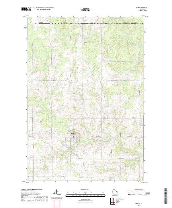 2022 Athens2022 Print · USGSMarathon County agricultural and timber lands surround the village of Athens in this recent survey. Local historians can trace property boundaries along Big Rib River and find landmarks like Lake Allu, Potato Cr, and old rural routes including Lovers Ln.
 - 2022 Map of Corinth, 2022 Print
 2022 Corinth2022 Print · USGSThe rural borders of Taylor and Marathon Counties come into focus in the early 2020s, showing a landscape defined by generational family farms. Local historians can trace the course of the E Br Big Eau Pleine River and find landmarks like Corinth and Windfall Hill Rd.
End of results
Showing maps 1-19 of 19
Top cities near Johnson
- Medford historical maps
- McMillan historical maps
- Spencer historical maps
- Stratford historical maps
- Edgar historical maps
- Abbotsford historical maps
See more
Top neighborhoods of Johnson
Frequently asked questions
- What are the different types of historical maps available for Johnson?
- What is the oldest map of Johnson?
- Where can I purchase historical maps of Johnson for my home or office?
- Where can I download high-res historical maps of Johnson?
- Are there historical topographic maps available for Johnson?
- Is there historical aerial imagery available for Johnson?
- Where are historical maps of Johnson sourced from?