1960s Maps of Stettin, Wisconsin
Explore 4 historic maps of Stettin from the 1960s. These maps offer a rare glimpse into what life looked like during the 1960s — showing old roads, neighborhoods, homes, and landmarks that have changed or disappeared over time.
Whether you're researching your family's past, planning a metal detecting trip, or studying how Stettin's landscape evolved across the 1960s, these high-resolution maps are a powerful tool for exploring the history of this region.
- Focus on a specific era: All maps on this page are from the 1960s, giving you a focused view of this time period.
- See what’s changed: Compare century-old streets, trails, and buildings to today's modern landscape using overlays and satellite layers.
- Research with precision: Use these maps for genealogy, historical research, land use analysis, or educational projects.
- View, download, or print: Maps are fully viewable online in high resolution, and can be downloaded or printed for your own records.
Start exploring Stettin's history through authentic maps from the 1960s. This is your window into the past.
Stettin, WI maps
(4)- 1963 Map of Wausau West, 1964 Print
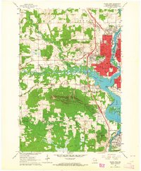 1963 Wausau West1964 Print · USGSWausau and the rugged Rib Mountain area are captured in the early sixties as the city expanded westward toward the township of Stettin. Local historians can trace the campuses of Newman High Sch and Mount View Sanatorium, or locate old rail lines of the Chicago and North Western.2 unique versions available
 - 1963 Map of Marathon, 1964 Print
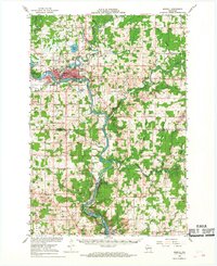
 1963 Marathon1964 Print · USGSMarathon County in the early sixties is a landscape of established dairy farms and developing recreation areas. Researchers can trace the rail-side growth of Edgar and Marathon City or locate rural landmarks like Daisy Dell Sch and Sacred Heart Ch Cem.
 - 1963 Map of Wausau, 1965 Print
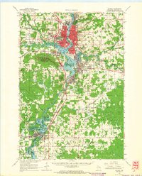 1963 Wausau1965 Print · USGSMarathon County’s river valley is caught in a moment of mid-century growth, centered on the bustling Wisconsin River industrial corridor. Genealogists and local historians can trace family locations near landmarks like St Agnes Ch Cem, the Mount View Sanatorium, and the small settlement of Peplin.2 unique versions available
 - 1966 Map of Merrill, 1968 Print
 1966 Merrill1968 Print · USGSMerrill and the river valleys of central Wisconsin are captured here in the mid-1960s as a thriving hub of rail and water-based industry. Genealogists can trace old family sites like Taegesville and Natterville or locate rural landmarks such as St James Cem and Mission Ch.2 unique versions available
End of results
Showing maps 1-4 of 4
Top cities near Stettin
- Wausau historical maps
- Weston historical maps
- Merrill historical maps
- Kronenwetter historical maps
- Rib Mountain historical maps
- Rothschild historical maps
See more
Frequently asked questions
- What are the different types of historical maps available for Stettin?
- What is the oldest map of Stettin?
- Where can I purchase historical maps of Stettin for my home or office?
- Where can I download high-res historical maps of Stettin?
- Are there historical topographic maps available for Stettin?
- Is there historical aerial imagery available for Stettin?
- Where are historical maps of Stettin sourced from?