1900-1909 Maps of Montello, Wisconsin
Explore 1 historic maps of Montello from 1900-1909. These maps offer a rare glimpse into what life looked like during the 1900s — showing old roads, neighborhoods, homes, and landmarks that have changed or disappeared over time.
Whether you're researching your family's past, planning a metal detecting trip, or studying how Montello's landscape evolved across the 1900s, these high-resolution maps are a powerful tool for exploring the history of this region.
- Focus on a specific era: All maps on this page are from the 1900s, giving you a focused view of this time period.
- See what’s changed: Compare century-old streets, trails, and buildings to today's modern landscape using overlays and satellite layers.
- Research with precision: Use these maps for genealogy, historical research, land use analysis, or educational projects.
- View, download, or print: Maps are fully viewable online in high resolution, and can be downloaded or printed for your own records.
Start exploring Montello's history through authentic maps from the 1900s. This is your window into the past.
Montello, WI maps
(1)- 1902 Map of Portage
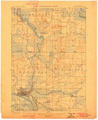 1902 Portage1902 Print · USGSPortage and the surrounding marshlands of Columbia County appear here at the turn of the century, centered on the strategic divide between the Wisconsin River and Fox River. Genealogists and rail historians can trace the early footprints of Portage, the canal-era site of Fort Hope, and rural communities like Pardeeville and Marcellon.3 unique versions available
End of results
Showing maps 1-1 of 1
Top cities near Montello
- Portage historical maps
- Montello historical maps
- Princeton historical maps
- Packwaukee historical maps
- Lewiston historical maps
- Marcellon historical maps
See more
Top neighborhoods of Montello
Frequently asked questions
- What are the different types of historical maps available for Montello?
- What is the oldest map of Montello?
- Where can I purchase historical maps of Montello for my home or office?
- Where can I download high-res historical maps of Montello?
- Are there historical topographic maps available for Montello?
- Is there historical aerial imagery available for Montello?
- Where are historical maps of Montello sourced from?