1970s Maps of Lima, Wisconsin
Explore 4 historic maps of Lima from the 1970s. These maps offer a rare glimpse into what life looked like during the 1970s — showing old roads, neighborhoods, homes, and landmarks that have changed or disappeared over time.
Whether you're researching your family's past, planning a metal detecting trip, or studying how Lima's landscape evolved across the 1970s, these high-resolution maps are a powerful tool for exploring the history of this region.
- Focus on a specific era: All maps on this page are from the 1970s, giving you a focused view of this time period.
- See what’s changed: Compare century-old streets, trails, and buildings to today's modern landscape using overlays and satellite layers.
- Research with precision: Use these maps for genealogy, historical research, land use analysis, or educational projects.
- View, download, or print: Maps are fully viewable online in high resolution, and can be downloaded or printed for your own records.
Start exploring Lima's history through authentic maps from the 1970s. This is your window into the past.
Lima, WI maps
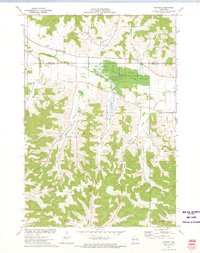
(4)- 1972 Map of Meridean, 1975 Print
 1972 Meridean1975 Print · USGSThe Chippewa River valley in the early seventies shows a landscape of fertile bottoms and rural townships. Researchers can trace family roots at Fossum Cem and Peru Cem or locate old school sites like Grandview Sch.
 - 1972 Map of Tarrant, 1975 Print
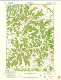
 1972 Tarrant1975 Print · USGSBuffalo County in the early seventies is a landscape of deeply carved valleys and conservation land. Genealogists and local historians can locate rural landmarks like Sacred Heart Cem, Tiffany Sch, and the small settlement of Tarrant.
 - 1972 Map of Durand North, 1975 Print
 1972 Durand North1975 Print · USGSThe Chippewa River valley in the early 1970s reveals a landscape of complex waterways and rail-side settlements. Researchers can trace the path of the Chicago Milwaukee St Paul and Pacific railroad past Dunnville or locate family sites like Evergreen Cem and Waubeek Mound.
 - 1972 Map of Durand South, 1975 Print
 1972 Durand South1975 Print · USGSThe river and rail corridor of the Chippewa River meets the rugged bluff country of Buffalo County during the early 1970s. Researchers can trace the path of the Chicago Milwaukee St Paul and Pacific RR or locate family sites at St Mary Cem and North Branch Cem.2 unique versions available
End of results
Showing maps 1-4 of 4
Top cities near Lima
- Menomonie historical maps
- Mondovi historical maps
- Union historical maps
- Red Cedar historical maps
- Durand historical maps
- Red Cedar historical maps
See more
Top neighborhoods of Lima
Frequently asked questions
- What are the different types of historical maps available for Lima?
- What is the oldest map of Lima?
- Where can I purchase historical maps of Lima for my home or office?
- Where can I download high-res historical maps of Lima?
- Are there historical topographic maps available for Lima?
- Is there historical aerial imagery available for Lima?
- Where are historical maps of Lima sourced from?