1970s Maps of Georgetown, Wisconsin
Explore 4 historic maps of Georgetown from the 1970s. These maps offer a rare glimpse into what life looked like during the 1970s — showing old roads, neighborhoods, homes, and landmarks that have changed or disappeared over time.
Whether you're researching your family's past, planning a metal detecting trip, or studying how Georgetown's landscape evolved across the 1970s, these high-resolution maps are a powerful tool for exploring the history of this region.
- Focus on a specific era: All maps on this page are from the 1970s, giving you a focused view of this time period.
- See what’s changed: Compare century-old streets, trails, and buildings to today's modern landscape using overlays and satellite layers.
- Research with precision: Use these maps for genealogy, historical research, land use analysis, or educational projects.
- View, download, or print: Maps are fully viewable online in high resolution, and can be downloaded or printed for your own records.
Start exploring Georgetown's history through authentic maps from the 1970s. This is your window into the past.
Georgetown, WI maps
(4)- 1971 Map of Kennan NW, 1973 Print
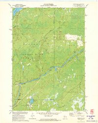 1971 Kennan NW1973 Print · USGSSawyer County's Northwoods are captured here in the early 1970s, showcasing the winding South Fork Flambeau River and its many rapids. Researchers can locate family landmarks and recreational sites like Connors Lake, Camp Flambeau, and the Cranberry Bog.2 unique versions available
 - 1971 Map of Kennan, 1973 Print
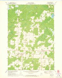 1971 Kennan1973 Print · USGSPrice County settlements thrived along the northern rail lines during the early seventies, centered on the villages of Kennan and Catawba. Genealogists and local historians can trace family locations through Kennan Cem, St Paul Ch, and the many family-named roads like Skinner Lane.
 - 1971 Map of Lac Sault Dore, 1973 Print
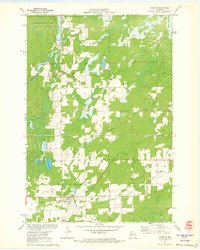
 1971 Lac Sault Dore1973 Print · USGSPrice County lake country was a mix of conservation and rural heritage in the early seventies. Genealogists and local historians can trace the Danish Settlement Road and locate landmarks like Wiemer Dam and McIlquham Lake.
 - 1971 Map of Hawkins, 1973 Print
 1971 Hawkins1973 Print · USGSRusk County in the early seventies shows a landscape of timber and rail focused on the village of Hawkins. Genealogists and local historians can trace family locations near the Hillcrest Cem, the National Ch, and the banks of the Hawkins Millpond.2 unique versions available
End of results
Showing maps 1-4 of 4
Top cities near Georgetown
- Phillips historical maps
- Fifield historical maps
- Ogema historical maps
- Hawkins historical maps
- Draper historical maps
- Kennan historical maps
See more
Frequently asked questions
- What are the different types of historical maps available for Georgetown?
- What is the oldest map of Georgetown?
- Where can I purchase historical maps of Georgetown for my home or office?
- Where can I download high-res historical maps of Georgetown?
- Are there historical topographic maps available for Georgetown?
- Is there historical aerial imagery available for Georgetown?
- Where are historical maps of Georgetown sourced from?