2020s Maps of Prentice, Wisconsin
Explore 5 historic maps of Prentice from the 2020s. These maps offer a rare glimpse into what life looked like during the 2020s — showing old roads, neighborhoods, homes, and landmarks that have changed or disappeared over time.
Whether you're researching your family's past, planning a metal detecting trip, or studying how Prentice's landscape evolved across the 2020s, these high-resolution maps are a powerful tool for exploring the history of this region.
- Focus on a specific era: All maps on this page are from the 2020s, giving you a focused view of this time period.
- See what’s changed: Compare century-old streets, trails, and buildings to today's modern landscape using overlays and satellite layers.
- Research with precision: Use these maps for genealogy, historical research, land use analysis, or educational projects.
- View, download, or print: Maps are fully viewable online in high resolution, and can be downloaded or printed for your own records.
Start exploring Prentice's history through authentic maps from the 2020s. This is your window into the past.
Prentice, WI maps
(5)- 2022 Map of Big Briens Lake, 2022 Print
 2022 Big Briens Lake2022 Print · USGSThe Northwoods of Price County are mapped here in the early twenty-first century, showing a remote landscape of winding rivers and timberland. Genealogists and local historians can trace family land via Nyberg Hill Rd, Knewston Rd, and the shores of Little Briens Lake.
 - 2022 Map of Timms Hill, 2022 Print
 2022 Timms Hill2022 Print · USGSNorthern Wisconsin's glacial landscape is documented here in the early twenty-first century, spanning the border of Price and Taylor counties. Researchers can trace the path of the Ice Age Trl past Timms Hill and locate the Garden of Memory Cem.
 - 2022 Map of Prentice, 2022 Print
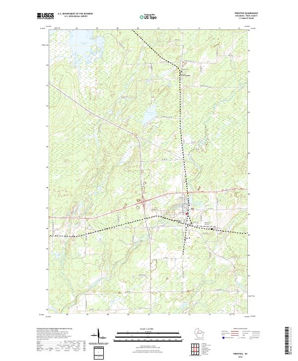 2022 Prentice2022 Print · USGSIn the Northwoods of Price County, this modern survey shows the village of Prentice and the nearby settlement of Worcester. Researchers can trace local lineage through the Hackett Cem or explore the waterways of the South Fork Jump River and Prentice Flowage 59.
 - 2022 Map of Pennington, 2022 Print
 2022 Pennington2022 Print · USGSPrice County settlement and wetland management are documented here in the early twenty-first century. Genealogists and local historians can trace property access near Pennington and along family-named routes like Moonshine Aly and Wears Rd.
 - 2022 Map of Ogema, 2022 Print
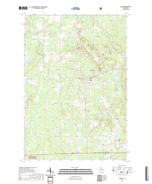 2022 Ogema2022 Print · USGSIn the heart of Price County, this 2022 survey captures the small-town character of Ogema and its surrounding timberlands. Genealogists and local historians can locate early burial sites like Hillside Cem and Will Cem, or trace the legacy of local industry at the Ogema Millpond.
End of results
Showing maps 1-5 of 5
Top cities near Prentice
- Worcester historical maps
- Phillips historical maps
- Ogema historical maps
- Rib Lake historical maps
- Westboro historical maps
- Prentice historical maps
See more
Top neighborhoods of Prentice
Frequently asked questions
- What are the different types of historical maps available for Prentice?
- What is the oldest map of Prentice?
- Where can I purchase historical maps of Prentice for my home or office?
- Where can I download high-res historical maps of Prentice?
- Are there historical topographic maps available for Prentice?
- Is there historical aerial imagery available for Prentice?
- Where are historical maps of Prentice sourced from?