1980s Maps of Richland County, Wisconsin
Explore 21 historic maps of Richland County from the 1980s. These maps offer a rare glimpse into what life looked like during the 1980s — showing old roads, neighborhoods, homes, and landmarks that have changed or disappeared over time.
Whether you're researching your family's past, planning a metal detecting trip, or studying how Richland County's landscape evolved across the 1980s, these high-resolution maps are a powerful tool for exploring the history of this region.
- Focus on a specific era: All maps on this page are from the 1980s, giving you a focused view of this time period.
- See what’s changed: Compare century-old streets, trails, and buildings to today's modern landscape using overlays and satellite layers.
- Research with precision: Use these maps for genealogy, historical research, land use analysis, or educational projects.
- View, download, or print: Maps are fully viewable online in high resolution, and can be downloaded or printed for your own records.
Start exploring Richland County's history through authentic maps from the 1980s. This is your window into the past.
Richland County, WI maps
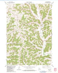
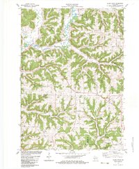
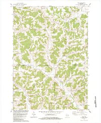
(21)- 1983 Map of Mt. Zion
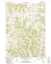
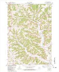 1983 Mt. Zion1983 Print · USGSThe rolling hills of Crawford and Richland counties are captured here in the early eighties. Genealogists and local historians can locate St Philips Ch, Tavera Cem, and the old Excelsior Sch among the namesake ridges.
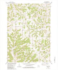
 - 1983 Map of Lime Ridge
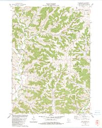
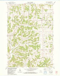 1983 Lime Ridge1983 Print · USGSRichland and Sauk Counties are captured in the early eighties as a patchwork of small dairy farms and rural townships. Genealogists and local historians can trace family roots through numerous sites like St Pauls Cem, the settlement of Sandusky, and Weston High Sch.
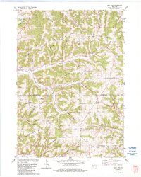
 - 1983 Map of Richland Center
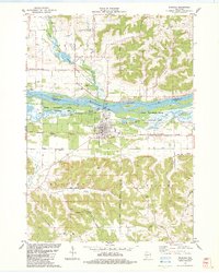
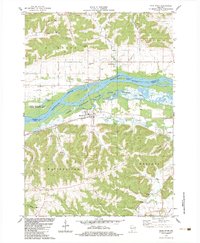
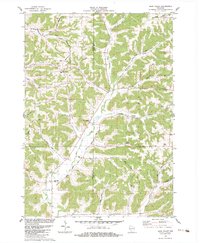
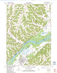
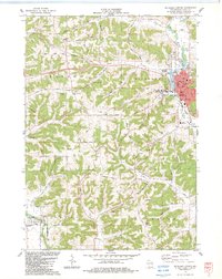 1983 Richland Center1983 Print · USGSRichland County in the early eighties centers on the river-and-rail hub of Richland Center and its surrounding ridge lands. Genealogists and local historians can trace rural family roots through sites like Dayton Corners, Oak Ridge Cem, and the Mayfield Cem.
 - 1983 Map of Sextonville
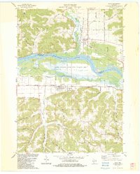
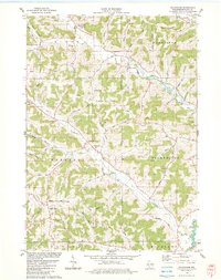
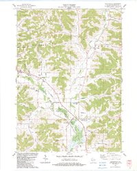 1983 Sextonville1983 Print · USGSThe Richland County countryside in the early eighties shows a transition from traditional valley farming to modern local infrastructure. Genealogists can trace family roots through the Willow Valley Cem, Neptune, and the Ash Creek Ch.
 - 1983 Map of Boaz
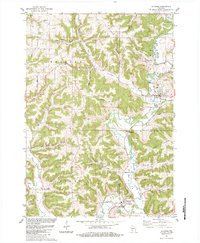
 1983 Boaz1983 Print · USGSRichland County's ridge-and-valley country is intricately mapped here in the early eighties, showing the rural landscape around the town of Boaz. Genealogists can locate family landmarks such as Conkle Cem, Fox Hollow Ch, and the settlement of Five Points.
 - 1983 Map of Muscoda
 1983 Muscoda1983 Print · USGSMuscoda and the river valley in the early eighties show a landscape of island sloughs and ridge-top farming. Trace local family roots at Pleasant Hill Cem, find rural landmarks like Eagle Corners, or follow the Fourth Principal Meridian.
 - 1983 Map of Lone Rock
 1983 Lone Rock1983 Print · USGSRichland County's riverfront and the bluffs of the Driftless Area are captured here in the early eighties. Researchers can trace the rail lines of the Chicago Milwaukee St Paul and Pacific or locate rural sites like Dixon Sch and Lone Rock Cem.
 - 1983 Map of Blue River
 1983 Blue River1983 Print · USGSThe Wisconsin River valley and the settlements of Blue River and Port Andrew are captured here in the early 1980s. Genealogists can trace family plots at Greenwood Cem or Beulah Cem, while the Wisconsin Western rail line marks the valley floor.
 - 1983 Map of Sabin
 1983 Sabin1983 Print · USGSThe townships of Sylvan and Bloom are captured here in the early 1980s, showcasing a landscape of deeply etched ridges and hollows. Genealogists can trace family landmarks at Ash Ridge Cem, Sylvan Sch, and the small settlement of Bosstown.
 - 1983 Map of Rockbridge
 1983 Rockbridge1983 Print · USGSRichland County at the start of the eighties reveals a network of tight valleys and ridge-top farms. Genealogists can locate family landmarks like Soules Creek Cem or Pleasant Ridge Ch alongside rural crossings in Hub City.
 - 1983 Map of Bear Valley
 1983 Bear Valley1983 Print · USGSSauk and Richland Counties are shown in the early eighties as a landscape of deep hollows and high ridges. Researchers can locate family landmarks such as St Killian Ch, the Ward Cem, and the industrial site of the Marble Quarry.
 - 1983 Map of Avoca
 1983 Avoca1983 Print · USGSThe Wisconsin River valley comes into sharp focus during the early eighties, showing the floodplain wetlands and the high ridges above the water. Genealogists can locate family landmarks like Avoca Cem, Fairview Ch, and the winding Snake Creek.
 - 1983 Map of Sugar Grove
 1983 Sugar Grove1983 Print · USGSThe Kickapoo River valley in the early 1980s reveals a landscape of high ridges and winding hollows at the junction of three counties. Trace family history at Sugar Grove or Kickapoo Center and locate rural landmarks like Berry Cem and Kickapoo High Sch.
 - 1983 Map of Boscobel
 1983 Boscobel1983 Print · USGSBoscobel and the surrounding river bottoms are captured here in the early 1980s as a vital corridor of rail transport and conservation. Researchers can trace old family landmarks and rural life through Plugtown, the St Patrick Cem, and the Maple Ridge Bible Ch.
 - 1983 Map of Gillingham
 1983 Gillingham1983 Print · USGSRichland County's ridge-and-valley country is shown here in the early eighties, centered on the rural junctions and family farmsteads of the driftless area. Researchers can locate numerous local burial sites including Bloom City Cem, English Ridge Cem, and Fancy Creek Cem.
 - 1983 Map of La Farge, 1984 Print
 1983 La Farge1984 Print · USGSThe Kickapoo Valley in the early eighties was a landscape of high ridges and tight hollows centered on La Farge and Viola. Researchers can trace old transportation routes like the Old Railroad Grade and locate ancestral sites at Star Cem or Chapel Hill Cem.
 - 1983 Map of Yuba, 1984 Print
 1983 Yuba1984 Print · USGSRichland and Vernon Counties appear here in the early 1980s, showcasing a landscape of deep coulees and ridge-top farms. Researchers can trace ancestral sites like Czechs National Cem and the settlement at White City along the Pine River.
 - 1983 Map of Valton, 1984 Print
 1983 Valton1984 Print · USGSThe tri-county border of Richland, Vernon, and Sauk counties comes into focus in the early 1980s, showcasing a landscape of high ridges and rural valleys. Researchers can trace family history at St Patricks Ch or locate family-named features like Benders Corners and Soules Creek.
 - 1983 Map of West Lima, 1984 Print
 1983 West Lima1984 Print · USGSThe Driftless Area of Vernon and Richland counties comes into focus in the early 1980s, showcasing the high-ridge farmsteads and narrow valleys of the Kickapoo region. Trace family history and rural routes through West Lima, Camp Creek Cem, and Maple Ridge.
 - 1985 Map of Sparta
 1985 Sparta1985 Print · USGSWestern Wisconsin in the 1980s shows the unique ridge-and-valley terrain of the Driftless Area during a period of transition for its rails and rural hubs. Trace the historic rail tunnels of the Elroy-Sparta State Trail and find local landmarks like St Marys Ch and Castle Rock Lake.2 unique versions available
 - 1985 Map of Richland Center, 1991 Print
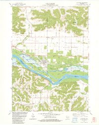
 1985 Richland Center1991 Print · USGSSouthwest Wisconsin’s driftless landscape in the mid-1980s is defined by its deep river valleys and tight agricultural settlements. Researchers can trace family-named landmarks like Mickelson Ridge or find remote churches and schools near Richland Center and Dodgeville.
End of results
Showing maps 1-21 of 21
Top cities of Richland County
- Richland Center historical maps
- Lone Rock historical maps
- Rockbridge historical maps
- Ithaca historical maps
- Orion historical maps
- Sylvan historical maps
See more
Frequently asked questions
- What are the different types of historical maps available for Richland County?
- What is the oldest map of Richland County?
- Where can I purchase historical maps of Richland County for my home or office?
- Where can I download high-res historical maps of Richland County?
- Are there historical topographic maps available for Richland County?
- Is there historical aerial imagery available for Richland County?
- Where are historical maps of Richland County sourced from?