1960s Maps of Hudson, Wisconsin
Explore 1 historic maps of Hudson from the 1960s. These maps offer a rare glimpse into what life looked like during the 1960s — showing old roads, neighborhoods, homes, and landmarks that have changed or disappeared over time.
Whether you're researching your family's past, planning a metal detecting trip, or studying how Hudson's landscape evolved across the 1960s, these high-resolution maps are a powerful tool for exploring the history of this region.
- Focus on a specific era: All maps on this page are from the 1960s, giving you a focused view of this time period.
- See what’s changed: Compare century-old streets, trails, and buildings to today's modern landscape using overlays and satellite layers.
- Research with precision: Use these maps for genealogy, historical research, land use analysis, or educational projects.
- View, download, or print: Maps are fully viewable online in high resolution, and can be downloaded or printed for your own records.
Start exploring Hudson's history through authentic maps from the 1960s. This is your window into the past.
Hudson, WI maps
(1)- 1967 Map of Hudson, 1969 Print
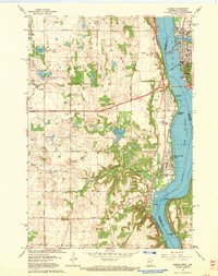 1967 Hudson1969 Print · USGSThe riverfront communities along the border of Minnesota and Wisconsin come to life in this survey from the late sixties. Genealogists and local historians can locate early landmarks like Bissels Mounds, Mount Prairie Cem, and the Lake Elmo Airport.4 unique versions available
End of results
Showing maps 1-1 of 1
Top cities near Hudson
- Woodbury historical maps
- Cottage Grove historical maps
- Hastings historical maps
- Stillwater historical maps
- River Falls historical maps
- Hugo historical maps
See more
Top neighborhoods of Hudson
- Eastport Carriage Homes historical maps
- Bieneman Farms historical maps
- Stonepine historical maps
- Villas of River Ridge historical maps
- Carmichael Ridge historical maps
- Sixth Street Historic District historical maps
See more
Frequently asked questions
- What are the different types of historical maps available for Hudson?
- What is the oldest map of Hudson?
- Where can I purchase historical maps of Hudson for my home or office?
- Where can I download high-res historical maps of Hudson?
- Are there historical topographic maps available for Hudson?
- Is there historical aerial imagery available for Hudson?
- Where are historical maps of Hudson sourced from?