1980s Maps of Reedsburg, Wisconsin
Explore 4 historic maps of Reedsburg from the 1980s. These maps offer a rare glimpse into what life looked like during the 1980s — showing old roads, neighborhoods, homes, and landmarks that have changed or disappeared over time.
Whether you're researching your family's past, planning a metal detecting trip, or studying how Reedsburg's landscape evolved across the 1980s, these high-resolution maps are a powerful tool for exploring the history of this region.
- Focus on a specific era: All maps on this page are from the 1980s, giving you a focused view of this time period.
- See what’s changed: Compare century-old streets, trails, and buildings to today's modern landscape using overlays and satellite layers.
- Research with precision: Use these maps for genealogy, historical research, land use analysis, or educational projects.
- View, download, or print: Maps are fully viewable online in high resolution, and can be downloaded or printed for your own records.
Start exploring Reedsburg's history through authentic maps from the 1980s. This is your window into the past.
Reedsburg, WI maps
(4)- 1983 Map of Loganville
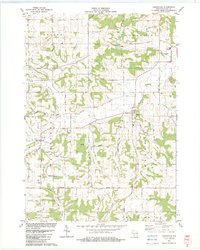 1983 Loganville1983 Print · USGSSauk County in the early eighties shows a settled landscape of family farms and rural parishes. Researchers can trace historic local boundaries and find sites like Tuckertown Cem, the County Home, and the winding Narrows Creek.
 - 1985 Map of Wisconsin Dells
 1985 Wisconsin Dells1985 Print · USGSCentral Wisconsin in the mid-eighties was a landscape of intricate river bends, rail junctions, and sprawling marshlands. Researchers can trace historic routes along the Soo Line or locate family landmarks near Lyndon Station, Buffalo Lake, and Puckaway Lake.
 - 1985 Map of Sparta
 1985 Sparta1985 Print · USGSWestern Wisconsin in the 1980s shows the unique ridge-and-valley terrain of the Driftless Area during a period of transition for its rails and rural hubs. Trace the historic rail tunnels of the Elroy-Sparta State Trail and find local landmarks like St Marys Ch and Castle Rock Lake.2 unique versions available
 - 1985 Map of Richland Center, 1991 Print
 1985 Richland Center1991 Print · USGSSouthwest Wisconsin’s driftless landscape in the mid-1980s is defined by its deep river valleys and tight agricultural settlements. Researchers can trace family-named landmarks like Mickelson Ridge or find remote churches and schools near Richland Center and Dodgeville.
End of results
Showing maps 1-4 of 4
Top cities near Reedsburg
- Reedsburg historical maps
- Lake Delton historical maps
- Wisconsin Dells historical maps
- Lemonweir historical maps
- Dell Prairie historical maps
- Town of Lyndon historical maps
See more
Frequently asked questions
- What are the different types of historical maps available for Reedsburg?
- What is the oldest map of Reedsburg?
- Where can I purchase historical maps of Reedsburg for my home or office?
- Where can I download high-res historical maps of Reedsburg?
- Are there historical topographic maps available for Reedsburg?
- Is there historical aerial imagery available for Reedsburg?
- Where are historical maps of Reedsburg sourced from?