1940s Maps of Saint Germain, Wisconsin
Explore 3 historic maps of Saint Germain from the 1940s. These maps offer a rare glimpse into what life looked like during the 1940s — showing old roads, neighborhoods, homes, and landmarks that have changed or disappeared over time.
Whether you're researching your family's past, planning a metal detecting trip, or studying how Saint Germain's landscape evolved across the 1940s, these high-resolution maps are a powerful tool for exploring the history of this region.
- Focus on a specific era: All maps on this page are from the 1940s, giving you a focused view of this time period.
- See what’s changed: Compare century-old streets, trails, and buildings to today's modern landscape using overlays and satellite layers.
- Research with precision: Use these maps for genealogy, historical research, land use analysis, or educational projects.
- View, download, or print: Maps are fully viewable online in high resolution, and can be downloaded or printed for your own records.
Start exploring Saint Germain's history through authentic maps from the 1940s. This is your window into the past.
Saint Germain, WI maps
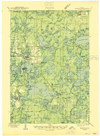
(3)- 1945 Map of Robbins, 1946 Print
 1945 Robbins1946 Print · USGSWisconsin's Northwoods come alive in this mid-century survey of the lake country around the Vilas and Oneida county line. Genealogists can trace family footprints through numerous rural schoolhouses like Lake Kathan Sch and forgotten sites like Wakefield and Robbins.
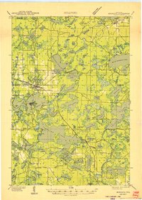
 - 1946 Map of Minocqua
 1946 Minocqua1946 Print · USGSThe Wisconsin Northwoods thrive in the mid-1940s, showing a landscape of glacial lakes and bustling rail-connected resort towns. Genealogists and local historians can trace rural institutions like Faulkner Sch, the State Fish Hatchery, and the Evergreen Ch.
 - 1949 Map of Minocqua
 1949 Minocqua1949 Print · USGSThe heart of the Wisconsin Northwoods is captured here at mid-century, defined by a dense tapestry of lakes and early railroad corridors. Genealogists and historians can trace family-named schools and early lakeside settlements like Arbor Vitae, Sayner, and Hazelhurst.
End of results
Showing maps 1-3 of 3
Top cities near Saint Germain
- Minocqua historical maps
- Newbold historical maps
- Sugar Camp historical maps
- Eagle River historical maps
- Hazelhurst historical maps
- Conover historical maps
See more
Frequently asked questions
- What are the different types of historical maps available for Saint Germain?
- What is the oldest map of Saint Germain?
- Where can I purchase historical maps of Saint Germain for my home or office?
- Where can I download high-res historical maps of Saint Germain?
- Are there historical topographic maps available for Saint Germain?
- Is there historical aerial imagery available for Saint Germain?
- Where are historical maps of Saint Germain sourced from?