1960s Maps of Bashaw, Wisconsin
Explore 3 historic maps of Bashaw from the 1960s. These maps offer a rare glimpse into what life looked like during the 1960s — showing old roads, neighborhoods, homes, and landmarks that have changed or disappeared over time.
Whether you're researching your family's past, planning a metal detecting trip, or studying how Bashaw's landscape evolved across the 1960s, these high-resolution maps are a powerful tool for exploring the history of this region.
- Focus on a specific era: All maps on this page are from the 1960s, giving you a focused view of this time period.
- See what’s changed: Compare century-old streets, trails, and buildings to today's modern landscape using overlays and satellite layers.
- Research with precision: Use these maps for genealogy, historical research, land use analysis, or educational projects.
- View, download, or print: Maps are fully viewable online in high resolution, and can be downloaded or printed for your own records.
Start exploring Bashaw's history through authentic maps from the 1960s. This is your window into the past.
Bashaw, WI maps
(3)- 1965 Map of Stillwater
 1965 Stillwater1965 Print · USGSThe Twin Cities and the St. Croix Valley are mapped here during a period of significant post-war growth and industrial transit. Genealogists and historians can trace rail lines like the Northern Pacific RR through towns such as Rush City, Amery, and Balsam Lake.
 - 1965 Map of Shell Lake, 1967 Print
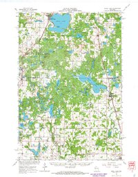 1965 Shell Lake1967 Print · USGSWisconsin's lake country in the mid-1960s is preserved here, centered on the rail-linked communities of Washburn and Barron Counties. Genealogists and historians can trace local landmarks like Heart Lake Church, Sarona Cemetery, and the Section Ten School.2 unique versions available
 - 1965 Map of Spooner, 1967 Print
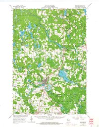 1965 Spooner1967 Print · USGSWashburn County's lakelands and rail corridors are frozen in time during the mid-sixties, centered on the bustling junction at Spooner. Researchers can trace the Chicago and North Western tracks to remote stops like Lampson, find the Evergreen Cem, or locate the old Schulz-Spooner School.
End of results
Showing maps 1-3 of 3
Top cities near Bashaw
- Spooner historical maps
- Cumberland historical maps
- Shell Lake historical maps
- Trego historical maps
- Beaver Brook historical maps
- Springbrook historical maps
See more
Frequently asked questions
- What are the different types of historical maps available for Bashaw?
- What is the oldest map of Bashaw?
- Where can I purchase historical maps of Bashaw for my home or office?
- Where can I download high-res historical maps of Bashaw?
- Are there historical topographic maps available for Bashaw?
- Is there historical aerial imagery available for Bashaw?
- Where are historical maps of Bashaw sourced from?