1960s Maps of Rushford, Wisconsin
Explore 4 historic maps of Rushford from the 1960s. These maps offer a rare glimpse into what life looked like during the 1960s — showing old roads, neighborhoods, homes, and landmarks that have changed or disappeared over time.
Whether you're researching your family's past, planning a metal detecting trip, or studying how Rushford's landscape evolved across the 1960s, these high-resolution maps are a powerful tool for exploring the history of this region.
- Focus on a specific era: All maps on this page are from the 1960s, giving you a focused view of this time period.
- See what’s changed: Compare century-old streets, trails, and buildings to today's modern landscape using overlays and satellite layers.
- Research with precision: Use these maps for genealogy, historical research, land use analysis, or educational projects.
- View, download, or print: Maps are fully viewable online in high resolution, and can be downloaded or printed for your own records.
Start exploring Rushford's history through authentic maps from the 1960s. This is your window into the past.
Rushford, WI maps
(4)- 1960 Map of Madison
 1960 Madison1960 Print · USGSCentral and Southern Wisconsin are captured in the late fifties, showing the region as its rail-and-river network matured. Trace the paths of the Soo Line RR or locate family roots near Lake Mendota and Horicon National Wildlife Refuge.2 unique versions available
 - 1961 Map of Poy Sippi, 1963 Print
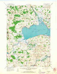 1961 Poy Sippi1963 Print · USGSThe Lake Poygan region of Wisconsin comes alive in this early 1960s survey, showing the intricate river-and-marsh economy before modern expansion. Researchers can trace family sites at Fountain Valley Sch & Ch, the Welsh Cem, or follow the banks of the Poy Sippi River through historic lakefront settlements like Tustin.2 unique versions available
 - 1961 Map of Auroraville, 1966 Print
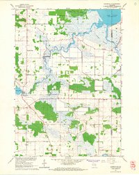 1961 Auroraville1966 Print · USGSWisconsin's wetlands and rural townships are captured here in the early sixties as the landscape transitioned between traditional farming and specialized bog cultivation. Trace family roots at the Welsh Cem or locate old community hubs like Fountain Valley and Auroraville.2 unique versions available
 - 1961 Map of Eureka, 1966 Print
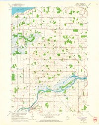 1961 Eureka1966 Print · USGSWinnebago County townships like Poygan and Rushford are captured in the early sixties as a network of river-side farms and rural schools. Researchers can trace family roots through several local landmarks like Oak Hill Cem and Liberty Sch.2 unique versions available
End of results
Showing maps 1-4 of 4
Top cities near Rushford
- Oshkosh historical maps
- Greenville historical maps
- Ripon historical maps
- City of Berlin historical maps
- Berlin historical maps
- Omro historical maps
See more
Top neighborhoods of Rushford
Frequently asked questions
- What are the different types of historical maps available for Rushford?
- What is the oldest map of Rushford?
- Where can I purchase historical maps of Rushford for my home or office?
- Where can I download high-res historical maps of Rushford?
- Are there historical topographic maps available for Rushford?
- Is there historical aerial imagery available for Rushford?
- Where are historical maps of Rushford sourced from?