Old Maps of Reno Junction, Wright
Explore 5 old maps of Reno Junction, spanning from 1955 to today. These high-resolution historic maps reveal how streets, neighborhoods, landmarks, and natural features evolved over time — perfect for genealogy, metal detecting, research, and local history exploration.
What you can do with these maps:
- See how Reno Junction changed over time: Compare historical maps to modern-day views to trace roads, homesites, rail lines & more.
- View detailed metadata: Each map includes creators, publishers, year, scale, and archive source.
- Overlay maps with satellite & LiDAR: Visualize the past alongside modern tools to explore terrain & human change.
- Trusted historical sources: Maps sourced from the USGS, Library of Congress, and other archives.
- Access maps your way: View online, download high-res files, or order prints for personal or research use.
Start exploring old maps of Reno Junction to uncover forgotten places, hidden landmarks, and the deep history beneath your feet.
Reno Junction, Wright maps
(5)- 1955 Map of Newcastle, 1963 Print
 1955 Newcastle1963 Print · USGSThe high plains of eastern Wyoming and western South Dakota are captured in the mid-fifties, showing a landscape of sprawling ranches and emerging oil fields. Researchers can locate family landmarks like Saunders Ranch, trace the Chicago Burlington & Quincy RR, and explore small rail towns such as Osage and Edgemont.2 unique versions available
 - 1958 Map of Newcastle
 1958 Newcastle1958 Print · USGSThe high plains of eastern Wyoming meet the Black Hills in the late fifties, showcasing a landscape of rail-connected towns and historic trails. Trace the path of the Chicago Burlington & Quincy RR through Newcastle or locate the Bozeman Trail Monument and Summitt Ridge Lookout Tower.
 - 1971 Map of Reno Junction, 1974 Print
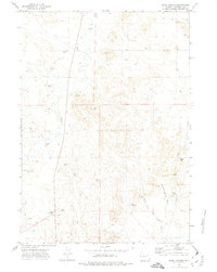 1971 Reno Junction1974 Print · USGSCampbell County ranching and early energy development are captured here in the early seventies, centered on the crossroads of Reno Junction. Genealogists and historians can locate family sites like Durham Ranch and Boller Ranch or trace the drainage of School Section Draw.
 - 1974 Map of Reno Junction, 1975 Print
 1974 Reno Junction1975 Print · USGSThe high plains of eastern Wyoming in the mid-1970s reveal an era of intensive energy production and remote ranching life. Genealogists and historians can trace the footprint of petroleum industry landmarks like the Hilight Oil and Gas Field alongside old settlements like Savageton and Reno.2 unique versions available
 - 2021 Map of Reno Junction, 2021 Print
 2021 Reno Junction2021 Print · USGSThe southern Powder River Basin comes into focus in this recent survey of Campbell County, where energy and ranching intersections meet. Genealogists and local historians can locate Wright, Reno Junction, and the Wright Cemetery near Sager Reservoir.
End of results
Showing maps 1-5 of 5
Top cities near Reno Junction
Frequently asked questions
- What are the different types of historical maps available for Reno Junction?
- What is the oldest map of Reno Junction?
- Where can I purchase historical maps of Reno Junction for my home or office?
- Where can I download high-res historical maps of Reno Junction?
- Are there historical topographic maps available for Reno Junction?
- Is there historical aerial imagery available for Reno Junction?
- Where are historical maps of Reno Junction sourced from?