Old Maps of Deadmans Corner, Wyoming
Explore 7 old maps of Deadmans Corner, spanning from 1949 to today. These high-resolution historic maps reveal how streets, neighborhoods, landmarks, and natural features evolved over time — perfect for genealogy, metal detecting, research, and local history exploration.
What you can do with these maps:
- See how Deadmans Corner changed over time: Compare historical maps to modern-day views to trace roads, homesites, rail lines & more.
- View detailed metadata: Each map includes creators, publishers, year, scale, and archive source.
- Overlay maps with satellite & LiDAR: Visualize the past alongside modern tools to explore terrain & human change.
- Trusted historical sources: Maps sourced from the USGS, Library of Congress, and other archives.
- Access maps your way: View online, download high-res files, or order prints for personal or research use.
Start exploring old maps of Deadmans Corner to uncover forgotten places, hidden landmarks, and the deep history beneath your feet.
Deadmans Corner, WY maps
(7)- 1949 Map of Shawnee, 1958 Print
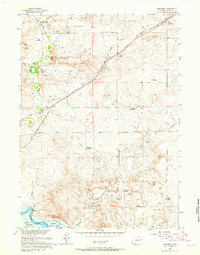
 1949 Shawnee1958 Print · USGSConverse County rangeland comes into focus in the late 1940s as the Missouri River Basin development project began. Genealogists can locate the local Cem near Shawnee or trace the early path of the Chicago and Northwestern railroad past Fisher.
 - 1950 Map of Shawnee
 1950 Shawnee1950 Print · USGSConverse County at the start of the 1950s shows a landscape organized by rail and river. Trace the development of small settlements like Shawnee and Fisher along the Chicago and Northwestern line near the North Platte River.
 - 1954 Map of Torrington, 1963 Print
 1954 Torrington1963 Print · USGSEastern Wyoming and the Nebraska borderlands are captured here during the mid-fifties, showing a landscape shaped by the Platte River and the Laramie Range. Researchers can trace deep history at the Fort Laramie National Historical Site, the Old Doty Ranch Site, and along the Old Fetterman Road.4 unique versions available
 - 1958 Map of Torrington
 1958 Torrington1958 Print · USGSEastern Wyoming and the Nebraska borderlands are captured in the late fifties, showcasing a landscape of high plains ranching and river-fed industry. Trace the historic paths of the Union Pacific railroad and find legacy sites like Fort Laramie and Sunrise.
 - 1961 Map of Shawnee, 1965 Print
 1961 Shawnee1965 Print · USGSHigh plains ranching and rail history meet in Converse County during the early sixties. Genealogists and historians can locate numerous family sites like the May Homestead and Kornegay Homestead near the historic Emigrant Trail.
 - 1981 Map of Douglas
 1981 Douglas1981 Print · USGSThe North Platte River corridor in the early eighties shows a landscape shaped by energy and iron. Genealogists and industrial historians can trace rail-side settlements like Glenrock, explore the Big Muddy Oil Field, and locate the old siding at Fetterman.
 - 2021 Map of Shawnee, 2021 Print
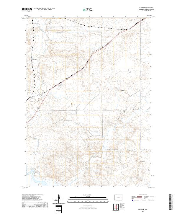 2021 Shawnee2021 Print · USGSIn the high plains of Converse County, this modern survey captures the rural landscape surrounding the settlement of Shawnee. Researchers can trace local topography and water rights near Glendo Reservoir, Twin Buttes, and the heights of Bobcat Hill.
End of results
Showing maps 1-7 of 7
Top cities near Deadmans Corner
Frequently asked questions
- What are the different types of historical maps available for Deadmans Corner?
- What is the oldest map of Deadmans Corner?
- Where can I purchase historical maps of Deadmans Corner for my home or office?
- Where can I download high-res historical maps of Deadmans Corner?
- Are there historical topographic maps available for Deadmans Corner?
- Is there historical aerial imagery available for Deadmans Corner?
- Where are historical maps of Deadmans Corner sourced from?