Old Maps of Seely, Wyoming
Explore 9 old maps of Seely, spanning from 1905 to today. These high-resolution historic maps reveal how streets, neighborhoods, landmarks, and natural features evolved over time — perfect for genealogy, metal detecting, research, and local history exploration.
What you can do with these maps:
- See how Seely changed over time: Compare historical maps to modern-day views to trace roads, homesites, rail lines & more.
- View detailed metadata: Each map includes creators, publishers, year, scale, and archive source.
- Overlay maps with satellite & LiDAR: Visualize the past alongside modern tools to explore terrain & human change.
- Trusted historical sources: Maps sourced from the USGS, Library of Congress, and other archives.
- Access maps your way: View online, download high-res files, or order prints for personal or research use.
Start exploring old maps of Seely to uncover forgotten places, hidden landmarks, and the deep history beneath your feet.
Seely, WY maps
(9)- 1905 Map of Devils Tower
 1905 Devils Tower1905 Print · USGSCrook County ranching and the northern Black Hills landscape are captured here in the early 1900s. Genealogists can trace early homesteading era holdings like Hulett Ranch and Yeasts Ranch near the landmark of Devils Tower.2 unique versions available
 - 1954 Map of Gillette, 1975 Print
 1954 Gillette1975 Print · USGSGillette and the northeast Wyoming ranching country are captured here in the mid-1950s as coal and bentonite mining shaped the local economy. Genealogists can trace family landmarks like the Bethlehem Church, Wellman School, and early settlements along the Chicago Burlington and Quincy RR.
 - 1955 Map of Gillette, 1976 Print
 1955 Gillette1976 Print · USGSNortheastern Wyoming in the mid-twentieth century is captured here as the energy and ranching landscape began to shift. Genealogists and historians can trace the foundations of local communities through sites like Wyodak, the Pleasantdale Community Building, and landmarks like Devils Tower National Monument.
 - 1957 Map of Seely, 1959 Print
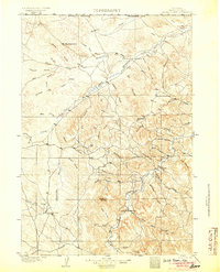
 1957 Seely1959 Print · USGSThe ranchlands of Crook County and the Montana border come alive in this mid-century survey of the upper Little Missouri River. Genealogists and historians can trace family homesteads like Ballou Ranch and Madden Ranch alongside rural landmarks like Seely and Johnson Sch.2 unique versions available
 - 1958 Map of Gillette
 1958 Gillette1958 Print · USGSNortheastern Wyoming and the Black Hills are captured here in the late fifties, showcasing a landscape of high-plains ranching and emerging energy production. Researchers can trace the rail-side growth of Gillette and find historic rural landmarks like the Wyodak Coal Mine, Bethlehem Church, and Devils Tower National Monument.2 unique versions available
 - 1962 Map of Gillette
 1962 Gillette1962 Print · USGSHigh plains ranching and coal mining dominate the Powder River Basin in the early sixties. Genealogists can trace rural communities through landmarks like the Bethlehem Church, Lake School, and settlements such as Moorcroft and Sundance.
 - 1979 Map of Devils Tower
 1979 Devils Tower1979 Print · USGSThe High Plains meet the Black Hills in the late 1970s, where the landmark Devils Tower rises above the Belle Fourche River. Trace the Chicago and North Western rail line and locate old outposts like Aladdin and Hulett.2 unique versions available
 - 1984 Map of Seely, 1985 Print
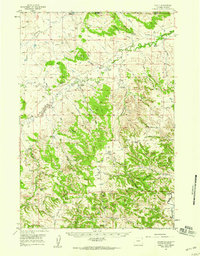
 1984 Seely1985 Print · USGSCrook County ranching life is well-documented in the 1980s as the landscape transitions toward the Black Hills. Researchers can trace remote homesteads and landmarks like Seely, Tromble Ranch Airfield, and the high point at Lovers Leap.
 - 2023 Map of Seely, 2023 Print
 2023 Seely2023 Print · USGSCrook County's high plains and canyons are captured here in the early twenty-first century, showing a remote landscape of prominent peaks and deep drainages. Trace local topography from Bear Buttes to the steep Government Canyon and the banks of the Belle Fourche River.
End of results
Showing maps 1-9 of 9
Top cities near Seely
Frequently asked questions
- What are the different types of historical maps available for Seely?
- What is the oldest map of Seely?
- Where can I purchase historical maps of Seely for my home or office?
- Where can I download high-res historical maps of Seely?
- Are there historical topographic maps available for Seely?
- Is there historical aerial imagery available for Seely?
- Where are historical maps of Seely sourced from?