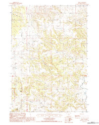
1984 Map of Seely
USGS Topo · Published 1985About this map
Seely and its surrounding ranchlands are documented here in the early 1980s, revealing a landscape defined by dramatic topography and seasonal watercourses. The Belle Fourche River snakes through the southeastern corner, serving as a primary drainage for numerous tributaries including Medicine Creek, Buck Creek, and Sourdough Creek. The terrain is deeply incised by landforms such as Government Canyon and Steam Engine Canyon, which separate the higher elevations of Bay Mtn and Lovers Leap from the lower creek beds.
Find a feature on this map
23 named features on this map. Tap any name to fly to it.
Don’t see what you’re looking for? This feature index may not catch every label — zoom into the map to look around manually.
Map Details
Editions of this 1984 Seely Map
This is the sole edition of this map. No revisions or reprints were ever made.
Other maps of this area

1901 · Aladdin
USGS Topo · 1:125,000

1903 · Aladdin
USGS Topo · 1:125,000

1905 · Devils Tower
USGS Topo · 1:125,000

1954 · Strawberry Hill
USGS Topo · 1:24,000

1954 · Storm Hill
USGS Topo · 1:24,000

1954 · Gillette
USGS Topo · 1:250,000

1955 · Devils Tower
USGS Topo · 1:62,500

1955 · Gillette
USGS Topo · 1:250,000

1957 · Mona
USGS Topo · 1:62,500

1957 · Seely
USGS Topo · 1:62,500