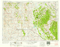
1954 Map of Gillette
USGS Topo · Published 1975About this map
Gillette stands as a central hub on this mid-century survey, surrounded by a landscape defined by resource extraction and high-plains agriculture. The industrial footprint of the region is evident at the Wyodak Coal Mine and several Bentonite Mines scattered near the Bear Lodge Mountains. Further research into the era's educational infrastructure is possible through the locations of the University of Wyoming Agricultural Experimental Station and rural institutions like the Thorn Divide School and Wellman School.
Find a feature on this map
180 named features on this map. Tap any name to fly to it.
Don’t see what you’re looking for? This feature index may not catch every label — zoom into the map to look around manually.
Map Details
Editions of this 1954 Gillette Map
This is the sole edition of this map. No revisions or reprints were ever made.
Historical Maps of Gillette Through Time
6 maps found