
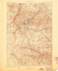
1901 Map of Deadwood
USGS Topo · Published 1901About this map
Deadwood and the surrounding gold-rich gulches of the northern Black Hills dominate this late-nineteenth-century survey. The map details a landscape defined by industrial extraction and military presence, from the Fort Meade Military Reservation near Sturgis to the numerous mining camps and post offices like Greenmont P.O. and Icebox P.O. that dot the high country. The Burlington and Missouri River Railroad and the Black Hills and Fort Pierre Railroad wind through the complex topography, connecting remote outposts like Rochford and Dumont to the larger hubs.
Find a feature on this map
143 named features on this map. Tap any name to fly to it.
Don’t see what you’re looking for? This feature index may not catch every label — zoom into the map to look around manually.
Map Details
Editions of this 1901 Deadwood Map
2 editions found
Other maps of this area

1893 · Rapid
USGS Topo · 1:125,000

1894 · Deadwood
USGS Topo · 1:125,000

1894 · Hermosa
USGS Topo · 1:125,000

1896 · Harney Peak
USGS Topo · 1:125,000

1898 · Sundance
USGS Topo · 1:125,000

1898 · Rapid
USGS Topo · 1:125,000

1899 · Sturgis
USGS Topo · 1:62,500

1899 · Newcastle
USGS Topo · 1:125,000

1900 · Spearfish
USGS Topo · 1:62,500

1901 · Hermosa
USGS Topo · 1:125,000