1901 Map of Deadwood
USGS Topo · Published 1906About this map
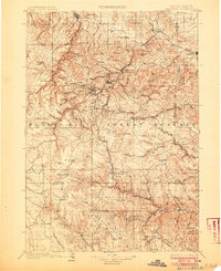
Deadwood and the surrounding gold-mining districts of the Black Hills Forest Reserve are captured here at the height of their industrial development. The map reveals the intricate network of narrow-gauge and standard railroads serving the mines, including the Deadwood Central RR and the Burlington and Missouri River RR. High-altitude settlements like Lead, Terraville, and Central sit atop the rich mineral veins of the northern hills, while lower-lying agricultural centers like Spearfish and Sturgis provide the necessary infrastructure for the region. A distinctive pattern of gulch-based settlements and isolated post offices, such as Greenmont P.O. and Icebox P.O., illustrates the scattered nature of early South Dakota prospecting. To the south, specialized industrial sites like the Omega Mine and Queen Bee Mines mark the deeper exploration into the southern reaches of Lawrence Co. and Pennington Co.
Find a feature on this map
183 named features on this map. Tap any name to fly to it.
Don’t see what you’re looking for? This feature index may not catch every label — zoom into the map to look around manually.
Map Details
Editions of this 1901 Deadwood Map
2 editions found

Other maps of this area

1893 · Rapid
USGS Topo · 1:125,000

1894 · Deadwood
USGS Topo · 1:125,000

1894 · Hermosa
USGS Topo · 1:125,000

1896 · Harney Peak
USGS Topo · 1:125,000

1898 · Sundance
USGS Topo · 1:125,000

1898 · Rapid
USGS Topo · 1:125,000

1899 · Sturgis
USGS Topo · 1:62,500

1899 · Newcastle
USGS Topo · 1:125,000

1900 · Spearfish
USGS Topo · 1:62,500

1901 · Hermosa
USGS Topo · 1:125,000