Old Maps of Barnum, Wyoming for Genealogy
Trace your family roots with 6 historic maps of Barnum. These high-res maps reveal old neighborhoods, homesites, landmarks, and streets — helping you uncover where your ancestors lived and how the area evolved over time.
- Explore historic neighborhoods: Identify where your relatives may have lived in the 1800s or 1900s.
- Compare maps over time: Trace the changes in streets, buildings, and landmarks for multi-generational research.
- Perfect for genealogy & ancestry research: Used by family historians and researchers to map out lineage and migration.
These maps are an incredible resource for exploring your personal connection to Barnum's past.
Barnum, WY maps
(6)- 1955 Map of Arminto, 1976 Print
 1955 Arminto1976 Print · USGSCentral Wyoming at the mid-century shows a landscape of energy reserves and high-plains ranching. Genealogists and historians can trace the Burlington Northern line through Lost Cabin and the famed Teapot Dome Naval Petroleum Reserve No 3.2 unique versions available
 - 1958 Map of Arminto
 1958 Arminto1958 Print · USGSCentral Wyoming in the late fifties was a landscape of high-plains energy and remote rail outposts. Researchers can trace the Chicago Burlington and Quincy railroad through towns like Arminto and Waltman or locate landmarks like Teapot Rock.
 - 1961 Map of Barnum, 1962 Print
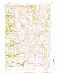 1961 Barnum1962 Print · USGSThe ranchlands of Johnson County come to life in this early 1960s survey of the iconic Powder River country. Genealogists and historians can trace the foundations of local legacy through sites like the Roy Rinker Homestead, Grave Ranch, and the legendary Outlaw Cave.2 unique versions available
 - 1962 Map of Arminto
 1962 Arminto1962 Print · USGSCentral Wyoming in the early sixties reveals a landscape shaped by the Chicago and North Western railroad and early energy development. Trace the history of the region through remote outposts like Arminto, the US Naval Petroleum Reserve, and the geologic landmark at Hells Half Acre.
 - 1984 Map of Barnum
 1984 Barnum1984 Print · USGSBarnum and the foothills of the Big Horns appear in this mid-seventies survey of Johnson County. Researchers can trace historical irrigation via the White Panther Ditch or locate landmarks like Castle Rock and the Minecke Trail.
 - 2021 Map of Barnum, 2021 Print
 2021 Barnum2021 Print · USGSThe community of Barnum and the surrounding Johnson County ranchlands are shown here in the 2020s. Researchers can trace historical water rights and land use via the Barnum Ditch, White Panther Ditch, and Blue Cr Ditch.
End of results
Showing maps 1-6 of 6
Frequently asked questions
- What are the different types of historical maps available for Barnum?
- What is the oldest map of Barnum?
- Where can I purchase historical maps of Barnum for my home or office?
- Where can I download high-res historical maps of Barnum?
- Are there historical topographic maps available for Barnum?
- Is there historical aerial imagery available for Barnum?
- Where are historical maps of Barnum sourced from?