Old Maps of Sussex, Wyoming for Genealogy
Trace your family roots with 5 historic maps of Sussex. These high-res maps reveal old neighborhoods, homesites, landmarks, and streets — helping you uncover where your ancestors lived and how the area evolved over time.
- Explore historic neighborhoods: Identify where your relatives may have lived in the 1800s or 1900s.
- Compare maps over time: Trace the changes in streets, buildings, and landmarks for multi-generational research.
- Perfect for genealogy & ancestry research: Used by family historians and researchers to map out lineage and migration.
These maps are an incredible resource for exploring your personal connection to Sussex's past.
Sussex, WY maps
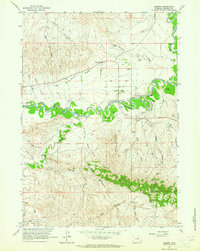
(5)- 1955 Map of Arminto, 1976 Print
 1955 Arminto1976 Print · USGSCentral Wyoming at the mid-century shows a landscape of energy reserves and high-plains ranching. Genealogists and historians can trace the Burlington Northern line through Lost Cabin and the famed Teapot Dome Naval Petroleum Reserve No 3.2 unique versions available
 - 1958 Map of Arminto
 1958 Arminto1958 Print · USGSCentral Wyoming in the late fifties was a landscape of high-plains energy and remote rail outposts. Researchers can trace the Chicago Burlington and Quincy railroad through towns like Arminto and Waltman or locate landmarks like Teapot Rock.
 - 1961 Map of Sussex, 1965 Print
 1961 Sussex1965 Print · USGSRanching life and early oil exploration meet along the winding Powder River in the early 1960s. Genealogists can trace family homesteads like the Patterson Ranch and the community center at Sussex School.2 unique versions available
 - 1962 Map of Arminto
 1962 Arminto1962 Print · USGSCentral Wyoming in the early sixties reveals a landscape shaped by the Chicago and North Western railroad and early energy development. Trace the history of the region through remote outposts like Arminto, the US Naval Petroleum Reserve, and the geologic landmark at Hells Half Acre.
 - 2021 Map of Sussex, 2021 Print
 2021 Sussex2021 Print · USGSThe settlement of Sussex sits at a critical junction of the Powder River and Salt Creek in recent years. Researchers can trace land use through the Sussex Irrigation Canal and family-named landmarks like Andrews Draw and Carpenter Draw.
End of results
Showing maps 1-5 of 5
Frequently asked questions
- What are the different types of historical maps available for Sussex?
- What is the oldest map of Sussex?
- Where can I purchase historical maps of Sussex for my home or office?
- Where can I download high-res historical maps of Sussex?
- Are there historical topographic maps available for Sussex?
- Is there historical aerial imagery available for Sussex?
- Where are historical maps of Sussex sourced from?