Old Maps of Acme, Wyoming
Explore 12 old maps of Acme, spanning from 1909 to today. These high-resolution historic maps reveal how streets, neighborhoods, landmarks, and natural features evolved over time — perfect for genealogy, metal detecting, research, and local history exploration.
What you can do with these maps:
- See how Acme changed over time: Compare historical maps to modern-day views to trace roads, homesites, rail lines & more.
- View detailed metadata: Each map includes creators, publishers, year, scale, and archive source.
- Overlay maps with satellite & LiDAR: Visualize the past alongside modern tools to explore terrain & human change.
- Trusted historical sources: Maps sourced from the USGS, Library of Congress, and other archives.
- Access maps your way: View online, download high-res files, or order prints for personal or research use.
Start exploring old maps of Acme to uncover forgotten places, hidden landmarks, and the deep history beneath your feet.
Acme, WY maps
(12)- 1909 Map of Sheridan, 1954 Print
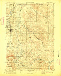
 1909 Sheridan1954 Print · USGSSheridan and the surrounding northern Wyoming ranchlands are captured here in the first decade of the twentieth century. Genealogists can trace family holdings at Wagoner Ranch or Big Red Ranch, and locate early rail stations like Verona and Ulm.2 unique versions available
 - 1911 Map of Sheridan
 1911 Sheridan1911 Print · USGSSheridan and the surrounding northern Wyoming ranchlands are captured here during a period of rapid railroad expansion. Researchers can trace the Chicago Burlington and Quincy RR through Dietz and Verona, or locate early homesteads like Wagoner Ranch.2 unique versions available
 - 1955 Map of Sheridan, 1973 Print
 1955 Sheridan1973 Print · USGSThe Bighorn Mountains meet the Powder River Basin in the 1950s, a period when cattle ranching and coal mining defined the regional economy. Genealogists and historians can trace local landmarks like the Fort Mackenzie Veteran Hospital, the Monarch Coal Mine, and legacy operations such as the Beckton Stock Farm.2 unique versions available
 - 1958 Map of Sheridan
 1958 Sheridan1958 Print · USGSThe Bighorn Mountains meet the high plains in the mid-1950s, revealing a landscape of large-scale ranching and mineral extraction. Trace the legacy of early settlements and industry through the Kleenburn Coal Tipple, Beckton Stock Farm, and the Hidden Dome Oil & Gas Field.2 unique versions available
 - 1962 Map of Sheridan
 1962 Sheridan1962 Print · USGSThe Big Horn Mountains and Powder River country are captured here in the early sixties as energy production and ranching shaped northern Wyoming. Researchers can locate specific sites like the Kleenburn Coal Tipple, Eaton Bros Ranch, and the Fort McKenzie Veteran Hospital.
 - 1968 Map of Acme, 1983 Print
 1968 Acme1983 Print · USGSSheridan County ranching and rail infrastructure are captured here in the late sixties, just as the region's transport networks were maturing. Local historians can trace the industrial layout of Acme and Kleenburn along the Tongue River and the Burlington Northern line.
 - 1979 Map of Sheridan
 1979 Sheridan1979 Print · USGSSheridan and the surrounding ranching country are captured in the late seventies as the region balanced its frontier heritage with new energy development. Researchers can trace the path of the Burlington Northern railroad and locate historic landmarks like Massacre Hill and Lodge Trail Ridge.
 - 2011 Map of Acme, 2011 Print
 2011 Acme2011 Print · USGSCovers Acme, including Sheridan County, Big Horn County, and other nearby areas
 - 2012 Map of Acme, 2012 Print
 2012 Acme2012 Print · USGSCovers Acme, including Sheridan County, Big Horn County, and other nearby areas
 - 2015 Map of Acme, 2015 Print
 2015 Acme2015 Print · USGSCovers Acme, including Sheridan County, Big Horn County, and other nearby areas
 - 2017 Map of Acme, 2017 Print
 2017 Acme2017 Print · USGSCovers Acme, including Sheridan County, Big Horn County, and other nearby areas
 - 2021 Map of Acme, 2021 Print
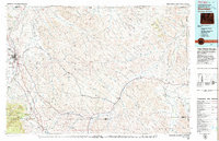
 2021 Acme2021 Print · USGSSheridan County, Wyoming, is shown here near the Montana border during the early twenty-first century. Researchers can trace the riverfront settlements of Acme and Kleenburn or locate landmarks like Gladewater Ditch and Beatty Gulch.
End of results
Showing maps 1-12 of 12
Top cities near Acme
Frequently asked questions
- What are the different types of historical maps available for Acme?
- What is the oldest map of Acme?
- Where can I purchase historical maps of Acme for my home or office?
- Where can I download high-res historical maps of Acme?
- Are there historical topographic maps available for Acme?
- Is there historical aerial imagery available for Acme?
- Where are historical maps of Acme sourced from?