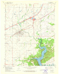
1971 Map of Afton
USGS Topo · Published 1973About this map
The town of Afton serves as the focal point of this 1970s survey, situated at the busy intersection of the St Louis-San Francisco railway and the Will Rogers Turnpike. The landscape transitions from the gridded streets of the settlement to the winding northern reaches of Lake O' the Cherokee, where Horse Creek Cove and Indian Hills meet the water. This era captures the region's transport-driven economy, evidenced by the large Afton Interchange and nearby Landing Strip. Local heritage is preserved in the location of family and community burial grounds, including Mt Hope Cem, Sixkiller Cem, and Ballard Cem near the town of Bernice. Further east, the label Oseuma marks a distinct point along the rail line, while the terrain's low-lying nature is highlighted by the network of creeks feeding into the reservoir.
Find a feature on this map
31 named features on this map. Tap any name to fly to it.
Don’t see what you’re looking for? This feature index may not catch every label — zoom into the map to look around manually.
Map Details
Editions of this 1971 Afton Map
This is the sole edition of this map. No revisions or reprints were ever made.
Other maps of this area

1901 · Vinita
USGS Topo · 1:125,000

1907 · Wyandotte
USGS Topo · 1:125,000

1909 · Wyandotte
USGS Topo · 1:125,000

1913 · Vinita
USGS Topo · 1:125,000

1954 · Tulsa
USGS Topo · 1:250,000

1958 · Tulsa
USGS Topo · 1:250,000

1961 · Miami SE
USGS Topo · 1:24,000

1961 · Miami SW
USGS Topo · 1:24,000

1963 · Tulsa
USGS Topo · 1:250,000
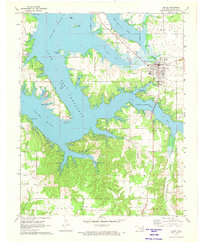
1971 · Grove
USGS Topo · 1:24,000