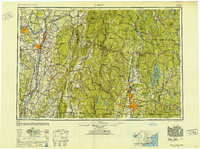
1948 Map of Albany
USGS Topo · Published 1951About this map
Industrial centers and natural resources converge across three states on this mid-century Army Map Service compilation. The confluence of the Hudson River and Mohawk River anchors the western portion of the map, highlighting the strategic positions of Schenectady, Albany, and Troy. This era shows the region's heavy reliance on its rail networks, specifically the Boston and Maine and Delaware and Hudson lines, which navigate the high terrain of the Hoosac Range and Adams Mountain.
Find a feature on this map
89 named features on this map. Tap any name to fly to it.
Don’t see what you’re looking for? This feature index may not catch every label — zoom into the map to look around manually.
Map Details
Editions of this 1948 Albany Map
This is the sole edition of this map. No revisions or reprints were ever made.
Other maps of this area

1885 · Northampton
USGS Topo · 1:62,500
1885 · Sheffield
USGS Topo · 1:62,500

1885 · Worcester
USGS Topo · 1:62,500

1886 · Greylock
USGS Topo · 1:62,500

1886 · Springfield
USGS Topo · 1:62,500

1886 · Hawley
USGS Topo · 1:62,500

1886 · Chesterfield
USGS Topo · 1:62,500

1886 · Worcester
USGS Topo · 1:62,500

1886 · Northampton
USGS Topo · 1:62,500
1886 · Becket
USGS Topo · 1:62,500