2023 Map of Alfred
USGS Topo · Published 2023About this map
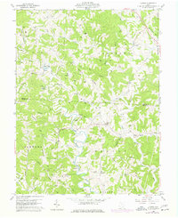
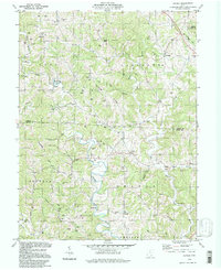
Middle Branch Shade River winds through this rural section of the Athens and Meigs county border, anchoring a landscape defined by prominent topographic features like Dutch Ridge and Jasper Hill. The settlement pattern is characterized by small, dispersed communities such as Alfred, Lottridge, and Sumner, which are connected by a network of township roads and ridges. Genealogists will find a high density of family and community burial sites, including the Lottridge Cem, Saint Johns Cem, and Orange Cem, reflecting the deep-rooted agricultural history of the region. The presence of Miller Airport near Bucks Mill and the East Branch Shade River suggests the continued importance of local aviation and water access in this hilly terrain. This survey provides a clear view of the ridges and hollows, such as Dog Hollow and Koppel Hollow, that have shaped transit and habitation in southeastern Ohio for generations.
Find a feature on this map
112 named features on this map. Tap any name to fly to it.
Don’t see what you’re looking for? This feature index may not catch every label — zoom into the map to look around manually.
Map Details
Editions of this 2023 Alfred Map
This is the sole edition of this map. No revisions or reprints were ever made.