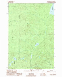
1989 Map of Allagash Pond
USGS Topo · Published 1989About this map
Chemquasabamticook Lake (Ross Lake) sits at the northeastern edge of this remote Maine township, feeding into Ross Inlet within the North Woods. The landscape is defined by its drainage patterns, with Maple Ridge serving as a central spine between various water bodies. To the south, the headwaters of the Allagash wilderness begin to take shape through the West Branch and Middle Branch Allagash Stream. This 1980s-era survey documents a region dominated by timber management and primitive access, as indicated by the sparse network of private roads. Named features like Allagash Pond, Fork Pond, and the aptly named Desolation Pond suggest a landscape largely untouched by permanent settlement, focused instead on the natural hydrology of the Somerset and Piscataquis county border.
Find a feature on this map
19 named features on this map. Tap any name to fly to it.
Don’t see what you’re looking for? This feature index may not catch every label — zoom into the map to look around manually.
Map Details
Editions of this 1989 Allagash Pond Map
This is the sole edition of this map. No revisions or reprints were ever made.
Other maps of this area

1954 · Baker Lake
USGS Topo · 1:62,500

1954 · Allagash Lake
USGS Topo · 1:62,500

1954 · Presque Isle
USGS Topo · 1:250,000

1955 · Beaver Pond
USGS Topo · 1:62,500

1955 · Clayton Lake
USGS Topo · 1:62,500

1958 · Presque Isle
USGS Topo · 1:250,000

1960 · Presque Isle
USGS Topo · 1:250,000

1961 · Allagash Lake
USGS Topo · 1:62,500

1962 · Baker Lake
USGS Topo · 1:62,500
1986 · Beaver Pond SE
USGS Topo · 1:24,000