
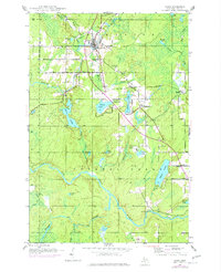
1945 Map of Amasa
USGS Topo · Published 1970About this map
Amasa serves as the central hub of this Upper Peninsula survey, situated at the junction of the Chicago Milwaukee St Paul and Pacific railroad and the Hemlock River. The landscape reveals a legacy of industrial activity in the Hematite district, most notably at the Warner Mine (abandoned) and Porter Mine (abandoned). These sites, along with several gravel pits, indicate the mineral extraction that once drove the local economy alongside the timber-rich river valleys.
Find a feature on this map
36 named features on this map. Tap any name to fly to it.
Don’t see what you’re looking for? This feature index may not catch every label — zoom into the map to look around manually.
Map Details
Editions of this 1945 Amasa Map
2 editions found
Other maps of this area

1895 · Ned Lake
USGS Topo · 1:62,500

1895 · Perch Lake
USGS Topo · 1:62,500

1898 · Iron River
USGS Topo · 1:62,500

1899 · Crystal Falls
USGS Topo · 1:62,500

1944 · Crystal Falls
USGS Topo · 1:24,000

1944 · Gaastra
USGS Topo · 1:24,000

1944 · Fortune Lakes
USGS Topo · 1:24,000

1945 · Sunset Lake
USGS Topo · 1:24,000

1945 · Kelso Junction
USGS Topo · 1:24,000

1946 · Sunset Lake
USGS Topo · 1:31,680