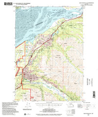
1994 Map of Anchorage B-7
USGS Topo · Published 2002About this map
The Alaska Railroad and Glenn Highway corridor serve as the backbone for development in this 1990s survey, connecting the settlements of Eagle River, Chugiak, and Eklutna. The map illustrates a landscape transitioning from the coastal mud of the Knik Arm and Palmer Hay Flats State Game Refuge to the dramatic peaks of Chugach State Park. Suburban growth is evident in the cluster of schools like Ernst Gruening Jr High School and civic infrastructure such as the Eklutna Water Treatment Plant.
Find a feature on this map
76 named features on this map. Tap any name to fly to it.
Don’t see what you’re looking for? This feature index may not catch every label — zoom into the map to look around manually.
Map Details
Editions of this 1994 Anchorage B-7 Map
This is the sole edition of this map. No revisions or reprints were ever made.
Other maps of this area

1950 · Anchorage C-8
USGS Topo · 1:63,360

1950 · Anchorage C-7
USGS Topo · 1:63,360

1951 · Anchorage
USGS Topo · 1:250,000

1951 · Anchorage C-6
USGS Topo · 1:63,360

1951 · Anchorage C-7
USGS Topo · 1:63,360

1952 · Anchorage C-7
USGS Topo · 1:63,360

1952 · Anchorage C-8
USGS Topo · 1:63,360

1952 · Anchorage A-8
USGS Topo · 1:63,360

1952 · Anchorage B-8
USGS Topo · 1:63,360

1953 · Anchorage A-8
USGS Topo · 1:63,360