
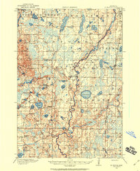
1991 Map of Anoka
USGS Topo · Published 1992About this map
The Mississippi River carves a diagonal path through this landscape, serving as a historic corridor for the Burlington Northern Railroad and the growth of river towns like Anoka, Elk River, and Monticello. To the north and east, the map reveals a transition from the developing suburban fringes of Coon Rapids and Blaine into the conserved wetlands and forests of the Sherburne National Wildlife Refuge and Carlos Avery State Wildlife Management Area. The western portion of the sheet is defined by the winding Crow River and its South Fork, which thread through agricultural lands and small lakefront communities such as St Michael and Buffalo Lake. This 1991 revision provides a clear picture of the region's expanding transportation network, including the heavy rail lines of the Soo Line Railroad and the burgeoning suburban layout around Maple Grove and Plymouth before the turn of the millennium.
Find a feature on this map
183 named features on this map. Tap any name to fly to it.
Don’t see what you’re looking for? This feature index may not catch every label — zoom into the map to look around manually.
Map Details
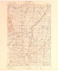
Editions of this 1991 Anoka Map
This is the sole edition of this map. No revisions or reprints were ever made.
Other maps of this area

1896 · Minneapolis
USGS Topo · 1:62,500

1896 · St. Paul
USGS Topo · 1:62,500

1901 · Minneapolis
USGS Topo · 1:62,500

1902 · White Bear
USGS Topo · 1:62,500

1902 · Anoka
USGS Topo · 1:62,500

1905 · Minnetonka
USGS Topo · 1:62,500

1907 · Minnetonka
USGS Topo · 1:62,500

1909 · Rockford
USGS Topo · 1:62,500
1916 · St. Francis
USGS Topo · 1:62,500
1919 · St. Francis
USGS Topo · 1:62,500